IMAGES TAKEN NEAR TO
Ring Road, LEEDS, LS15 7AA
Introduction
This page details the photographs taken nearby to Ring Road, LS15 7AA by members of the Geograph project.
The Geograph project started in 2005 with the aim of publishing, organising and preserving representative images for every square kilometre of Great Britain, Ireland and the Isle of Man.

There are currently over 7.5m images from over14,400 individuals and you can help contribute to the project by visiting https://www.geograph.org.uk
Image Map (Loading...)


Getting Data...Please wait
Leaflet Map data © OpenStreetMap
Images are licensed for reuse under creativecommons.org/licenses/by-sa/2.0
Notes
- Clicking on the map will re-center to the selected point.
- The higher the marker number, the further away the image location is from the centre of the postcode.
Image Listing (122 Images Found)
Images are licensed for reuse under creativecommons.org/licenses/by-sa/2.0
Image
Details
Distance
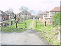
2

Kennerleigh Glen - Kennerleigh Walk
Image: © Betty Longbottom
Taken: 1 Apr 2015
0.05 miles
5
End of Hollyshaw Walk, formerly Green Lane
Image: © Nigel Glew
Taken: 15 Mar 2002
0.09 miles
6
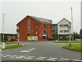
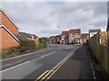
Crossgates Medical Centre
Entering Crossgates from the south, this modern facility marks the beginning of the town centre as residential gives way to commercial estate.
Image: © Stephen Craven
Taken: 30 Sep 2023
0.09 miles
7
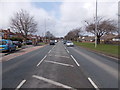
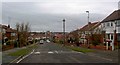
Ring Road - viewed from Kingswear Parade
Image: © Betty Longbottom
Taken: 1 Apr 2015
0.10 miles
8
Hollyshaw Crescent - Hollyshaw Lane
Image: © Betty Longbottom
Taken: 1 Apr 2015
0.11 miles
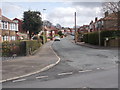
9
Knightsway Whitkirk, Leeds
Looking down towards Cross Gates.
Image: © Steve Fareham
Taken: 23 Feb 2009
0.11 miles