IMAGES TAKEN NEAR TO
Main Street, LEEDS, LS15 4DN
Introduction
This page details the photographs taken nearby to Main Street, LS15 4DN by members of the Geograph project.
The Geograph project started in 2005 with the aim of publishing, organising and preserving representative images for every square kilometre of Great Britain, Ireland and the Isle of Man.

There are currently over 7.5m images from over14,400 individuals and you can help contribute to the project by visiting https://www.geograph.org.uk
Image Map (Loading...)


Getting Data...Please wait
Leaflet Map data © OpenStreetMap
Images are licensed for reuse under creativecommons.org/licenses/by-sa/2.0
Notes
- Clicking on the map will re-center to the selected point.
- The higher the marker number, the further away the image location is from the centre of the postcode.
Image Listing (52 Images Found)
Images are licensed for reuse under creativecommons.org/licenses/by-sa/2.0
Image
Details
Distance
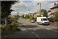
1
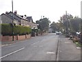
Main Street - viewed from Grange Court
Image: © Betty Longbottom
Taken: 20 Oct 2015
0.01 miles
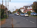
2
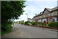
Main Street near St. Philip's Church
Houses along Main Street in Scholes.
Image: © DS Pugh
Taken: 3 Aug 2024
0.02 miles
3
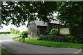
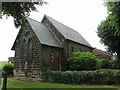
St. Philip's Church
There are two Church buildings here, this old Church and a much newer building.
Image: © DS Pugh
Taken: 3 Aug 2024
0.02 miles
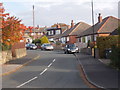
7
Main Street - viewed from Grange Court
Image: © Betty Longbottom
Taken: 20 Oct 2015
0.03 miles
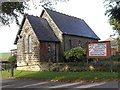
9
St. Philip's Church, Scholes
Modern Anglican church, located on Main Street in Scholes
Image: © Chris Heaton
Taken: 9 Apr 2017
0.05 miles
10
A walk from Oulton Church #48
St Philip's Church, Scholes.
Image: © Ian S
Taken: 14 Aug 2010
0.06 miles