IMAGES TAKEN NEAR TO
Rakehill Road, LEEDS, LS15 4AL
Introduction
This page details the photographs taken nearby to Rakehill Road, LS15 4AL by members of the Geograph project.
The Geograph project started in 2005 with the aim of publishing, organising and preserving representative images for every square kilometre of Great Britain, Ireland and the Isle of Man.

There are currently over 7.5m images from over14,400 individuals and you can help contribute to the project by visiting https://www.geograph.org.uk
Image Map (Loading...)


Getting Data...Please wait
Leaflet Map data © OpenStreetMap
Images are licensed for reuse under creativecommons.org/licenses/by-sa/2.0
Notes
- Clicking on the map will re-center to the selected point.
- The higher the marker number, the further away the image location is from the centre of the postcode.
Image Listing (58 Images Found)
Images are licensed for reuse under creativecommons.org/licenses/by-sa/2.0
Image
Details
Distance
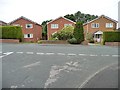
1
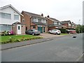
Arthursdale Grange, Arthursdale
A small housing estate at the north end of Scholes.
Image: © Christine Johnstone
Taken: 25 Jul 2012
0.05 miles
3
Road to the Buffers
The Buffers is a pub in the former Scholes Railway Station on the long dismantled Cross Gates–Wetherby line. For more information on the former railway see: https://en.wikipedia.org/wiki/Cross_Gates%E2%80%93Wetherby_line and for information on the railway station see: https://en.wikipedia.org/wiki/Scholes_railway_station
Image: © DS Pugh
Taken: 3 Aug 2024
0.07 miles
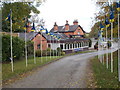
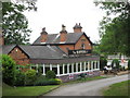
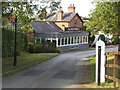
5
Scholes railway station (site), Yorkshire
Opened in 1876 by the North Eastern Railway on its line from Leeds to Wetherby, this station closed in 1964. View north towards Thorner and Wetherby, the station building (beyond the fence) was converted into a pub/restaurant in 1979 with a railway carriage alongside the original platform as part of the experience. The carriage was removed in 1999 and after repairs is in service in the Keighley and Worth Valley Railway. The former goods yard serves as the pub car park.
A full history of the station and the railway line, together with photos of the station before and after closure, can be found at http://www.disused-stations.org.uk/s/scholes/index.shtml.
Image: © Nigel Thompson
Taken: 9 Apr 2012
0.07 miles
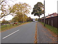
6
Detached houses on The Approach
Opposite Arthursdale Grange, at the northern end of Scholes.
Image: © Christine Johnstone
Taken: 25 Jul 2012
0.08 miles
7
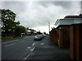
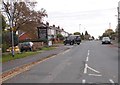
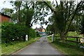
A walk from Oulton Church #51
Walking down Rakehill Road.
Image: © Ian S
Taken: 14 Aug 2010
0.08 miles
8
The Buffers pub, Scholes
The former Scholes station building, opened in 1876 and closed to passengers in 1964, is now a Marstons pub. See Image for a closer view.
Image: © Stephen Craven
Taken: 14 Sep 2019
0.08 miles