IMAGES TAKEN NEAR TO
Coniston Gardens, LEEDS, LS15 0BL
Introduction
This page details the photographs taken nearby to Coniston Gardens, LS15 0BL by members of the Geograph project.
The Geograph project started in 2005 with the aim of publishing, organising and preserving representative images for every square kilometre of Great Britain, Ireland and the Isle of Man.

There are currently over 7.5m images from over14,400 individuals and you can help contribute to the project by visiting https://www.geograph.org.uk
Image Map
Images are licensed for reuse under creativecommons.org/licenses/by-sa/2.0
Notes
- Clicking on the map will re-center to the selected point.
- The higher the marker number, the further away the image location is from the centre of the postcode.
Image Listing (67 Images Found)
Images are licensed for reuse under creativecommons.org/licenses/by-sa/2.0
Image
Details
Distance
1
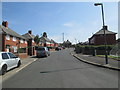
Firbank Grove - Ullswater Crescent
Image: © Betty Longbottom
Taken: 25 Jul 2014
0.04 miles
4
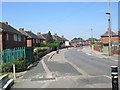
Ullswater Crescent - viewed from Kendal Drive
Image: © Betty Longbottom
Taken: 25 Jul 2014
0.08 miles
5
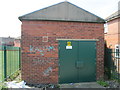
Electricity Substation No 2093 - Ullswater Crescent
Image: © Betty Longbottom
Taken: 25 Jul 2014
0.08 miles
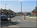
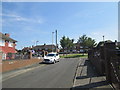
7

Ullswater Crescent - viewed from Coronation Parade
Image: © Betty Longbottom
Taken: 24 Jun 2014
0.10 miles
8

Firbank Grove - looking towards Westminster Crescent
Image: © Betty Longbottom
Taken: 24 Jun 2014
0.10 miles
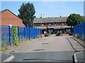
9
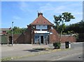
Mace - The Grocer - Halton Moor Road
Image: © Betty Longbottom
Taken: 25 Jul 2014
0.11 miles
10
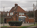
MACE store on Halton Moor Road
The shop is just called "The Grocer" and is part of the MACE chain of convenience stores.
Image: © Stephen Craven
Taken: 26 Feb 2017
0.11 miles