IMAGES TAKEN NEAR TO
Wharf Approach, LEEDS, LS1 4FB
Introduction
This page details the photographs taken nearby to Wharf Approach, LS1 4FB by members of the Geograph project.
The Geograph project started in 2005 with the aim of publishing, organising and preserving representative images for every square kilometre of Great Britain, Ireland and the Isle of Man.

There are currently over 7.5m images from over14,400 individuals and you can help contribute to the project by visiting https://www.geograph.org.uk
Image Map
Images are licensed for reuse under creativecommons.org/licenses/by-sa/2.0
Notes
- Clicking on the map will re-center to the selected point.
- The higher the marker number, the further away the image location is from the centre of the postcode.
Image Listing (1116 Images Found)
Images are licensed for reuse under creativecommons.org/licenses/by-sa/2.0
Image
Details
Distance
1
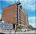
New building on Water Lane
The redevelopment of what is now being called 'Holbeck Urban Village' continues apace. This new building occupies the site of the former Water Hall Mills.
Image: © Stephen Craven
Taken: 8 Jun 2021
0.01 miles
2
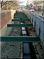
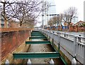
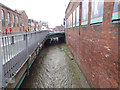
The Hol Beck
Since the industrial development of the area, the beck has been contained in an artificial channel, but with plenty of space for storm water.
Image: © Alan Murray-Rust
Taken: 11 Dec 2017
0.01 miles
5
The Hol Beck, Water Lane, Leeds
The area of Holbeck takes its name from the Hol Beck, which is seen here tamed into nothing much more than a drain alongside Water Lane. In the early industrial era, it would have provided water power for some of the industry that grew up here to the south of the city centre.
Image: © Rich Tea
Taken: 12 Apr 2007
0.02 miles
6
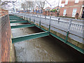
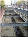
The Hol Beck after a wet night (1)
Compare another photo of the same location alongside Water Lane in dry weather Image
Image: © Stephen Craven
Taken: 10 Mar 2018
0.02 miles
7
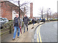
Nine men went to snap...
... went to snap a photo. Altogether eleven of us (but sadly no dog) on this Geograph group walk setting off from the railway station in the direction of Middleton.
The brick wall to the left was probable the outer wall of the Tower Works, though beyond it all that remained at the time of this photos was cleared land used as a car park. It was demolished the following year to make way for a new development.
Image: © Stephen Craven
Taken: 10 Mar 2018
0.02 miles
8
The Hol Beck after a wet night (2)
Compare another photo of a nearby location alongside Water Lane in dry weather Image
Image: © Stephen Craven
Taken: 10 Mar 2018
0.03 miles
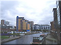
9
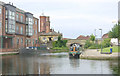
Granary Wharf, Leeds
Granary Wharf in Leeds is above the first lock on the Leeds and Liverpool Canal.
Image: © Martin Clark
Taken: Unknown
0.03 miles