IMAGES TAKEN NEAR TO
Dragon Close, LEEDS, LS14 6WG
Introduction
This page details the photographs taken nearby to Dragon Close, LS14 6WG by members of the Geograph project.
The Geograph project started in 2005 with the aim of publishing, organising and preserving representative images for every square kilometre of Great Britain, Ireland and the Isle of Man.

There are currently over 7.5m images from over14,400 individuals and you can help contribute to the project by visiting https://www.geograph.org.uk
Image Map
Images are licensed for reuse under creativecommons.org/licenses/by-sa/2.0
Notes
- Clicking on the map will re-center to the selected point.
- The higher the marker number, the further away the image location is from the centre of the postcode.
Image Listing (21 Images Found)
Images are licensed for reuse under creativecommons.org/licenses/by-sa/2.0
Image
Details
Distance
1
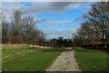
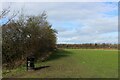
Footpath in Primrose Valley Local Nature Reserve
One of several footpaths that cross Primrose Valley - this one heading towards Cross Gates
Image: © Chris Heaton
Taken: 23 Feb 2022
0.11 miles
2
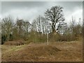
Sewer vent in Halton Deans
This pipe with a wire cage is most likely a sewer vent, and there is probably a manhole within this vegetation-covered mound.
Image: © Stephen Craven
Taken: 14 Mar 2021
0.12 miles
3
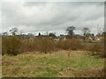
New housing at Seacroft, from across the railway
The site of the former Seacroft Hospital is now being redeveloped for housing, seen here from Primrose Valley Park to the south (the farm that gave its name to the park has been demolished but would have been in this view, just this side of the railway fencing that can be seen between the bushes).
Image: © Stephen Craven
Taken: 14 Mar 2021
0.15 miles
4
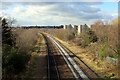
Railway Lines between Halton and Killingbeck
Lines heading west towards Leeds City Station, as seen on the footbridge by Sutton Approach.
This is where the Wyke Beck green corridor crosses.
Image: © Chris Heaton
Taken: 23 Feb 2022
0.15 miles
5
In Primrose Valley Local Nature Reserve
Image: © Chris Heaton
Taken: 23 Feb 2022
0.18 miles
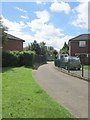
7
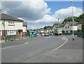
Watson Road - viewed from Collin Road
Image: © Betty Longbottom
Taken: 10 Jun 2014
0.18 miles
8
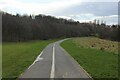
Cycleway and Footpath in Primrose Valley Park
Wide tarmac thoroughfare divided equally between walkers and cyclists heading towards Halton
Image: © Chris Heaton
Taken: 23 Feb 2022
0.19 miles
10
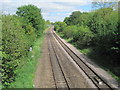
York-Leeds railway line from Sutton Approach footbridge
View east.
Image: © Nigel Thompson
Taken: 19 May 2013
0.20 miles