IMAGES TAKEN NEAR TO
Parkway Towers, LEEDS, LS14 6UX
Introduction
This page details the photographs taken nearby to Parkway Towers, LS14 6UX by members of the Geograph project.
The Geograph project started in 2005 with the aim of publishing, organising and preserving representative images for every square kilometre of Great Britain, Ireland and the Isle of Man.

There are currently over 7.5m images from over14,400 individuals and you can help contribute to the project by visiting https://www.geograph.org.uk
Image Map
Images are licensed for reuse under creativecommons.org/licenses/by-sa/2.0
Notes
- Clicking on the map will re-center to the selected point.
- The higher the marker number, the further away the image location is from the centre of the postcode.
Image Listing (45 Images Found)
Images are licensed for reuse under creativecommons.org/licenses/by-sa/2.0
Image
Details
Distance
1
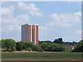
Parkway Towers
The only high rise block on the otherwise low-rise Brooklands estate, viewed from Fearnville Fields recreation ground.
Image: © Stephen Craven
Taken: 7 Jul 2018
0.00 miles
2
Parkway Towers, Leeds
Seen from Fearnville, across the valley of Wyke Beck.
Image: © Christine Johnstone
Taken: 21 Nov 2012
0.01 miles
3
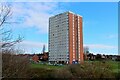
Parkway Towers, Seacroft
As seen from the Wyke Beck green corridor on the Fearnville Playing Fields. Constructed by Wimpy in the 1960's, there are 99 dwellings arranged on 17 storeys.
Image: © Chris Heaton
Taken: 23 Feb 2022
0.01 miles
4

Electricity Substation No 3794 - off Brooklands Crescent
Image: © Betty Longbottom
Taken: 3 Jun 2014
0.02 miles
5
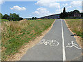
Wykebeck Way - unequal widths?
Usually a segregated-use cycle/footpath is split evenly across its width. Here, an existing path has been used but not widened, so the cycle track is allocated its usual width (probably 1.5m) and the footpath ends up very narrow. In practice it makes little difference.
Image: © Stephen Craven
Taken: 7 Jul 2018
0.04 miles
6

Brooklands Crescent - Foundry Mill Drive
Image: © Betty Longbottom
Taken: 3 Jun 2014
0.05 miles
7

Brooklands Avenue - Brooklands Crescent
Image: © Betty Longbottom
Taken: 3 Jun 2014
0.05 miles
8
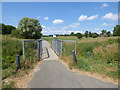
Footbridge on the Wykebeck Way in Fearnville Fields
The metal bridge carries a shared-use cycle/footpath.
Image: © Stephen Craven
Taken: 7 Jul 2018
0.05 miles
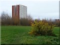
9
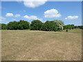
Fearnville Fields (3) - trees
A belt of trees marks the boundary between the middle and top levels of playing fields on Fearnville Fields recreation ground.
Image: © Stephen Craven
Taken: 7 Jul 2018
0.08 miles
10
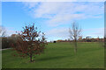
Fearnville Playing Fields
Local sporting facilities and recreation ground
Image: © Chris Heaton
Taken: 23 Feb 2022
0.08 miles