IMAGES TAKEN NEAR TO
Rosgill Walk, LEEDS, LS14 6QR
Introduction
This page details the photographs taken nearby to Rosgill Walk, LS14 6QR by members of the Geograph project.
The Geograph project started in 2005 with the aim of publishing, organising and preserving representative images for every square kilometre of Great Britain, Ireland and the Isle of Man.

There are currently over 7.5m images from over14,400 individuals and you can help contribute to the project by visiting https://www.geograph.org.uk
Image Map
Images are licensed for reuse under creativecommons.org/licenses/by-sa/2.0
Notes
- Clicking on the map will re-center to the selected point.
- The higher the marker number, the further away the image location is from the centre of the postcode.
Image Listing (46 Images Found)
Images are licensed for reuse under creativecommons.org/licenses/by-sa/2.0
Image
Details
Distance
8
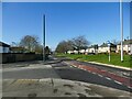
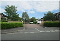
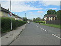
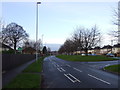
North Parkway, looking west
One of the spine roads of a large area of post-war housing in Seacroft. The wide central verge may have been passive provision for a future tram line that was never built.
Image: © Stephen Craven
Taken: 24 Feb 2024
0.09 miles