IMAGES TAKEN NEAR TO
Brooklands Lane, LEEDS, LS14 6QG
Introduction
This page details the photographs taken nearby to Brooklands Lane, LS14 6QG by members of the Geograph project.
The Geograph project started in 2005 with the aim of publishing, organising and preserving representative images for every square kilometre of Great Britain, Ireland and the Isle of Man.

There are currently over 7.5m images from over14,400 individuals and you can help contribute to the project by visiting https://www.geograph.org.uk
Image Map
Images are licensed for reuse under creativecommons.org/licenses/by-sa/2.0
Notes
- Clicking on the map will re-center to the selected point.
- The higher the marker number, the further away the image location is from the centre of the postcode.
Image Listing (45 Images Found)
Images are licensed for reuse under creativecommons.org/licenses/by-sa/2.0
Image
Details
Distance
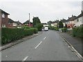
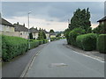
2
Brooklands Lane - looking towards Brooklands Avenue
Image: © Betty Longbottom
Taken: 3 Jun 2014
0.03 miles
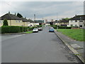
6
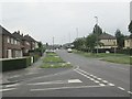
Kentmere Avenue - viewed from Easdale Road
Image: © Betty Longbottom
Taken: 3 Jun 2014
0.09 miles
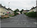
8
Kentmere Avenue - viewed from Easdale Road
Image: © Betty Longbottom
Taken: 3 Jun 2014
0.09 miles
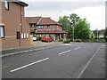
9
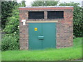
Electricity Substation No 791 - Brooklands Avenue
Image: © Betty Longbottom
Taken: 3 Jun 2014
0.11 miles
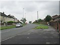
10
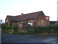
Seacroft Congregational Church
In a state of disrepair. Looks like the lead has been pinched.
Image: © JThomas
Taken: 14 Dec 2013
0.12 miles