IMAGES TAKEN NEAR TO
Cherry Blossom Rise, LEEDS, LS14 6GU
Introduction
This page details the photographs taken nearby to Cherry Blossom Rise, LS14 6GU by members of the Geograph project.
The Geograph project started in 2005 with the aim of publishing, organising and preserving representative images for every square kilometre of Great Britain, Ireland and the Isle of Man.

There are currently over 7.5m images from over14,400 individuals and you can help contribute to the project by visiting https://www.geograph.org.uk
Image Map
Images are licensed for reuse under creativecommons.org/licenses/by-sa/2.0
Notes
- Clicking on the map will re-center to the selected point.
- The higher the marker number, the further away the image location is from the centre of the postcode.
Image Listing (59 Images Found)
Images are licensed for reuse under creativecommons.org/licenses/by-sa/2.0
Image
Details
Distance
5
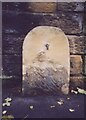
Old Milestone, A64, York Road, Killingbeck
Opposite Asda, just E of Watson Road. Located back to the wall near the bus stop. Stone post (plate lost). Brayshaw & Booth iron casting.
Lost since 2000.
Tadcaster 11 / Leeds 3
Milestone Society National ID: YW_TCLE11
Image: © Christine Minto
Taken: 4 Feb 2006
0.08 miles
6
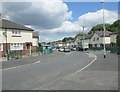
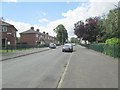
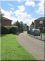
Watson Road - viewed from Collin Road
Image: © Betty Longbottom
Taken: 10 Jun 2014
0.08 miles
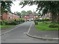
8
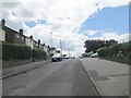
Collin Road - viewed from Watson Road
Image: © Betty Longbottom
Taken: 10 Jun 2014
0.10 miles
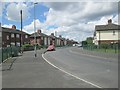
10
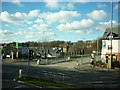
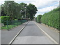
The junction of Oak Tree Lane and the A64 York Road
Image: © Ian S
Taken: 10 Feb 2011
0.11 miles