IMAGES TAKEN NEAR TO
York Road, LEEDS, LS14 6AT
Introduction
This page details the photographs taken nearby to York Road, LS14 6AT by members of the Geograph project.
The Geograph project started in 2005 with the aim of publishing, organising and preserving representative images for every square kilometre of Great Britain, Ireland and the Isle of Man.

There are currently over 7.5m images from over14,400 individuals and you can help contribute to the project by visiting https://www.geograph.org.uk
Image Map
Images are licensed for reuse under creativecommons.org/licenses/by-sa/2.0
Notes
- Clicking on the map will re-center to the selected point.
- The higher the marker number, the further away the image location is from the centre of the postcode.
Image Listing (65 Images Found)
Images are licensed for reuse under creativecommons.org/licenses/by-sa/2.0
Image
Details
Distance
5
Wild Wild West - York Road
This is an adventure feature for children.
Image: © Betty Longbottom
Taken: 22 Sep 2007
0.09 miles
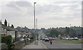
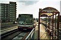
7
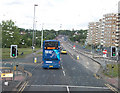
York Road (A64) out of Leeds at the Junction of Wykebeck Valley Road
The guided bus way to the right of the Coastliner runs down the middle of the A64 from this junction to the ASDA at Killingbeck.
Image: © Leslie
Taken: 12 May 2011
0.11 miles
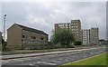
8
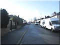
Harrison Crescent - Wykebeck Valley Road
Image: © Betty Longbottom
Taken: 4 Feb 2014
0.11 miles
9
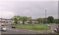
Road junction and roundabout on Selby Road
From railway
Image: © John Firth
Taken: 10 May 2014
0.12 miles