IMAGES TAKEN NEAR TO
Ainsley View, LEEDS, LS14 5QN
Introduction
This page details the photographs taken nearby to Ainsley View, LS14 5QN by members of the Geograph project.
The Geograph project started in 2005 with the aim of publishing, organising and preserving representative images for every square kilometre of Great Britain, Ireland and the Isle of Man.

There are currently over 7.5m images from over14,400 individuals and you can help contribute to the project by visiting https://www.geograph.org.uk
Image Map
Images are licensed for reuse under creativecommons.org/licenses/by-sa/2.0
Notes
- Clicking on the map will re-center to the selected point.
- The higher the marker number, the further away the image location is from the centre of the postcode.
Image Listing (47 Images Found)
Images are licensed for reuse under creativecommons.org/licenses/by-sa/2.0
Image
Details
Distance
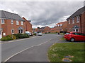
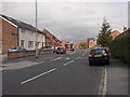
1
Ainsley View, Swarcliffe
A relatively new cul de sac off Stanks Drive.
Image: © Richard Vince
Taken: 18 Feb 2017
0.03 miles
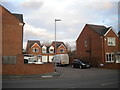
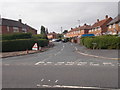
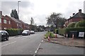
2
Stanks Drive, Swarcliffe
One of the main distributor roads through the estate.
Image: © Richard Vince
Taken: 18 Feb 2017
0.03 miles
3
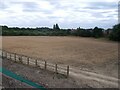
Farmland east of Swarcliffe
I presume this land will be developed for infill housing in the coming years.
Image: © Stephen Craven
Taken: 26 Aug 2022
0.07 miles
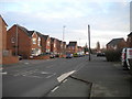
4
Stanks Drive - viewed from Stanks Rise
Image: © Betty Longbottom
Taken: 22 Aug 2015
0.09 miles
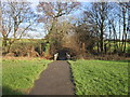
5
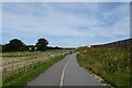
Cycle path approaching Wood Lane Bridge
A cycle path runs along the west side of the East Leeds Orbital Route. Ahead is Wood Lane Bridge.
Image: © DS Pugh
Taken: 3 Aug 2024
0.10 miles
6
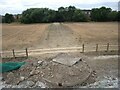
Culverted stream
Until recently this was an open stream, but it has been culverted under the new orbital road (behind the photographer) and also across the next field, which is probably allocated for housing development.
Image: © Stephen Craven
Taken: 26 Aug 2022
0.10 miles
9
Stanks Drive - viewed from Stanks Rise
Image: © Betty Longbottom
Taken: 22 Aug 2015
0.11 miles