IMAGES TAKEN NEAR TO
Whinmoor Way, LEEDS, LS14 5DL
Introduction
This page details the photographs taken nearby to Whinmoor Way, LS14 5DL by members of the Geograph project.
The Geograph project started in 2005 with the aim of publishing, organising and preserving representative images for every square kilometre of Great Britain, Ireland and the Isle of Man.

There are currently over 7.5m images from over14,400 individuals and you can help contribute to the project by visiting https://www.geograph.org.uk
Image Map
Images are licensed for reuse under creativecommons.org/licenses/by-sa/2.0
Notes
- Clicking on the map will re-center to the selected point.
- The higher the marker number, the further away the image location is from the centre of the postcode.
Image Listing (62 Images Found)
Images are licensed for reuse under creativecommons.org/licenses/by-sa/2.0
Image
Details
Distance

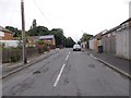
2
Sherburn Road, Whinmoor
On the skyline is ferrybridge power station.
Image: © Ian S
Taken: 28 Jan 2012
0.04 miles

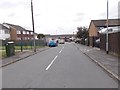
5
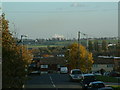
Looking down Sherburn Road North towards Stanks Drive
Ferrybridge cooling towers and chimneys in the background and the matrix signs on the A1 (M1) link road. Both the bus stops on Sherburn Road North are visible.
Image: © Leslie
Taken: 9 Nov 2006
0.04 miles