IMAGES TAKEN NEAR TO
Sedgegarth, LEEDS, LS14 3LB
Introduction
This page details the photographs taken nearby to Sedgegarth, LS14 3LB by members of the Geograph project.
The Geograph project started in 2005 with the aim of publishing, organising and preserving representative images for every square kilometre of Great Britain, Ireland and the Isle of Man.

There are currently over 7.5m images from over14,400 individuals and you can help contribute to the project by visiting https://www.geograph.org.uk
Image Map
Images are licensed for reuse under creativecommons.org/licenses/by-sa/2.0
Notes
- Clicking on the map will re-center to the selected point.
- The higher the marker number, the further away the image location is from the centre of the postcode.
Image Listing (127 Images Found)
Images are licensed for reuse under creativecommons.org/licenses/by-sa/2.0
Image
Details
Distance
2
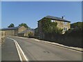
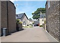
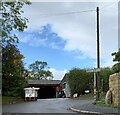
Manor Farm, Thorner
The farm comprised buildings either side of the road and would have been on the edge of the village at one time. The architectural interest is not so much in the farmhouse shown here, as in the large medieval barn glimpsed in the distance, which is listed as 'a rare and important survival in the region'. To the left of this photo, some of the farm buildings appear to have been converted to apartments.
Image: © Stephen Craven
Taken: 10 Jun 2023
0.03 miles
5
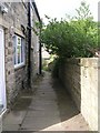
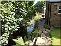
Footpath from Church view, Thorner, leading to Victory Hall
Image: © Betty Longbottom
Taken: 3 Sep 2008
0.05 miles
8
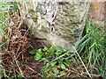
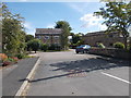
Thorner, Station Road
The benchmark is cut into a lone stone post on the north side of Station Road. The mark was hidden by the spoil built up against the post.
Image: © Mel Towler
Taken: 7 Oct 2022
0.06 miles
9
Thorner, Station Road
There is a benchmark cut into the lone stone post on the north side of Station Road. The mark was hidden by the spoil built up against the post.
Image: © Mel Towler
Taken: 7 Oct 2022
0.06 miles
10
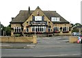
The Mexborough Arms - Main Street, Thorner
Image: © Betty Longbottom
Taken: 3 Sep 2008
0.06 miles