IMAGES TAKEN NEAR TO
Kirkhills, LEEDS, LS14 3JD
Introduction
This page details the photographs taken nearby to Kirkhills, LS14 3JD by members of the Geograph project.
The Geograph project started in 2005 with the aim of publishing, organising and preserving representative images for every square kilometre of Great Britain, Ireland and the Isle of Man.

There are currently over 7.5m images from over14,400 individuals and you can help contribute to the project by visiting https://www.geograph.org.uk
Image Map
Images are licensed for reuse under creativecommons.org/licenses/by-sa/2.0
Notes
- Clicking on the map will re-center to the selected point.
- The higher the marker number, the further away the image location is from the centre of the postcode.
Image Listing (97 Images Found)
Images are licensed for reuse under creativecommons.org/licenses/by-sa/2.0
Image
Details
Distance
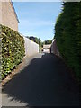
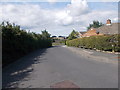
2
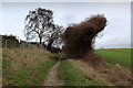
Leeds Country Way outside Thorner
Following the southern boundary of the village
Image: © Chris Heaton
Taken: 28 Jan 2016
0.03 miles
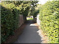
3
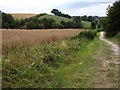
Rapeseed near Thorner
With Kirkfield Lane, carrying the Leeds Country Way, on the right.
Image: © Derek Harper
Taken: 1 Aug 2011
0.05 miles
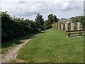
8
Kirk Hills - viewed from Kirkfield Lane
Image: © Betty Longbottom
Taken: 17 Aug 2015
0.09 miles
9
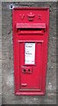
Victorian Post Box - Church Hill, Thorner
Image: © Betty Longbottom
Taken: 3 Sep 2008
0.10 miles