IMAGES TAKEN NEAR TO
Ling Lane, LEEDS, LS14 3HX
Introduction
This page details the photographs taken nearby to Ling Lane, LS14 3HX by members of the Geograph project.
The Geograph project started in 2005 with the aim of publishing, organising and preserving representative images for every square kilometre of Great Britain, Ireland and the Isle of Man.

There are currently over 7.5m images from over14,400 individuals and you can help contribute to the project by visiting https://www.geograph.org.uk
Image Map
Images are licensed for reuse under creativecommons.org/licenses/by-sa/2.0
Notes
- Clicking on the map will re-center to the selected point.
- The higher the marker number, the further away the image location is from the centre of the postcode.
Image Listing (15 Images Found)
Images are licensed for reuse under creativecommons.org/licenses/by-sa/2.0
Image
Details
Distance
1
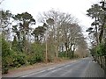
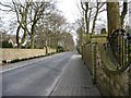
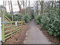
Mixed woodland, north side of Ling Lane
This is someone's front garden.
Image: © Christine Johnstone
Taken: 7 Apr 2013
0.04 miles
3
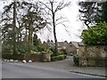
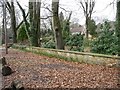
Entrance to Stone Lodge, Ling Lane
One of the smaller properties along the lane.
Image: © Christine Johnstone
Taken: 7 Apr 2013
0.05 miles
4
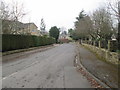
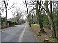
Looking eastwards along Ling Lane
Full of big, well-protected houses.
Image: © Christine Johnstone
Taken: 7 Apr 2013
0.09 miles
5
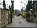
Houses on the north side of Ling Lane
Seen from the entrance to Hunters Close.
Image: © Christine Johnstone
Taken: 7 Apr 2013
0.11 miles
6
Silver Birches, Ling Lane
A very private development of flats on what was one house plot.
Image: © Christine Johnstone
Taken: 7 Apr 2013
0.13 miles
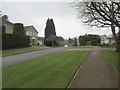
7
Looking westwards along Ling Lane
At the site of the 137 metres spot height.
Image: © Christine Johnstone
Taken: 7 Apr 2013
0.14 miles
9
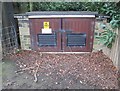
Electricity Substation No 4014 - Ling Lane
Image: © Betty Longbottom
Taken: 16 Mar 2015
0.15 miles