IMAGES TAKEN NEAR TO
Bramham Road, LEEDS, LS14 3ET
Introduction
This page details the photographs taken nearby to Bramham Road, LS14 3ET by members of the Geograph project.
The Geograph project started in 2005 with the aim of publishing, organising and preserving representative images for every square kilometre of Great Britain, Ireland and the Isle of Man.

There are currently over 7.5m images from over14,400 individuals and you can help contribute to the project by visiting https://www.geograph.org.uk
Image Map
Images are licensed for reuse under creativecommons.org/licenses/by-sa/2.0
Notes
- Clicking on the map will re-center to the selected point.
- The higher the marker number, the further away the image location is from the centre of the postcode.
Image Listing (25 Images Found)
Images are licensed for reuse under creativecommons.org/licenses/by-sa/2.0
Image
Details
Distance
1
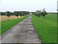
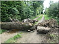
Nova Scotia.
Farm near Bramham Park.
Image: © Steve Partridge
Taken: 2 Sep 2006
0.05 miles
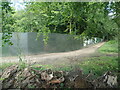
3
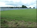
Security fence at Nova Scotia Farm
Erected to prevent trespass at Leeds Festival. Seen from Mangrill Lane.
Image: © Christine Johnstone
Taken: 15 Aug 2023
0.07 miles
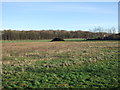
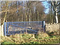
5
Barrier on Mangrill Lane, near Nova Scotia
Mangrill Lane runs along the western boundary of Bramham Park. The lane is a public bridleway, which had been legally closed 4th - 31st August 2023, because of the Leeds Festival at Bramham Park. There was a closure notice at each end of the lane but not at the junction with the Thorner Moor footpath, which is the way I had come. This barrier is intended to deter trespass within Bramham Park.
Image: © Christine Johnstone
Taken: 15 Aug 2023
0.13 miles
6
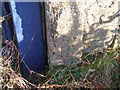
Benchmark on a gatepost beside Mangrill Lane
Image: © John Slater
Taken: 9 Jan 2013
0.14 miles
7
Gate beside Mangrill Lane
Blue seems to be the Bramham Estate colour. The right hand side of the gate is the location of Image
Image: © John Slater
Taken: 9 Jan 2013
0.14 miles
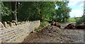
8
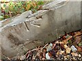
Thorner, Mangrill Lane PROW
The broken concrete post with a damaged benchmark has been removed from the boundary wall of Bramham Estate during wall repairs. The broken post is part of a spoil heap between the boundary wall and the footpath. Sad to see.
Image: © Mel Towler
Taken: 7 Oct 2022
0.14 miles
9
Thorner, Mangrill Lane
The broken concrete post with a damaged benchmark has been removed from the boundary wall of Bramham Estate during wall repairs. The broken post is part of a spoil heap between the boundary wall and the footpath. Sad to see.
Image: © Mel Towler
Taken: 7 Oct 2022
0.14 miles
10
Security fence, Thorner Moor Plantation, Bramham Park
Erected for the Leeds Festival and seen from Mangrill Lane. The lane is a public bridleway, which had been legally closed 4th - 31st August 2023, because of the Leeds Festival at Bramham Park. There was a closure notice at each end of the lane but not at the junction with the Thorner Moor footpath, which is the way I had come. The track by the fence is not a public right of way.
Image: © Christine Johnstone
Taken: 15 Aug 2023
0.16 miles