IMAGES TAKEN NEAR TO
Bramham Road, LEEDS, LS14 3ER
Introduction
This page details the photographs taken nearby to Bramham Road, LS14 3ER by members of the Geograph project.
The Geograph project started in 2005 with the aim of publishing, organising and preserving representative images for every square kilometre of Great Britain, Ireland and the Isle of Man.

There are currently over 7.5m images from over14,400 individuals and you can help contribute to the project by visiting https://www.geograph.org.uk
Image Map
Images are licensed for reuse under creativecommons.org/licenses/by-sa/2.0
Notes
- Clicking on the map will re-center to the selected point.
- The higher the marker number, the further away the image location is from the centre of the postcode.
Image Listing (9 Images Found)
Images are licensed for reuse under creativecommons.org/licenses/by-sa/2.0
Image
Details
Distance
1
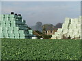
Bale stacks at Kelfield Grange farm
A small part of the huge stack of bales at the farm, with the farmhouse just visible through the gap.
Image: © Gordon Hatton
Taken: 31 Oct 2022
0.04 miles
2
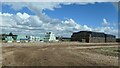
Bales wrapped and unwrapped, Thorner Moor
At Kelfield Grange.
Image: © Christine Johnstone
Taken: 15 Aug 2023
0.08 miles
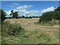
3
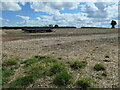
Public footpath heading south-east, Thorner Moor
Crossing an oilseed rape stubble field, just south of Kelfield Grange. This footpath is shown on the large-scale OS map surveyed in 1845-7.
Image: © Christine Johnstone
Taken: 15 Aug 2023
0.11 miles
4
Public footpath heading north-east, Thorner Moor
This footpath is shown on the large-scale OS map surveyed in 1845-7.
Image: © Christine Johnstone
Taken: 15 Aug 2023
0.12 miles
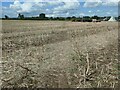
5
Farmland east of Thorner
About 105 metres above sea level.
Image: © Christine Johnstone
Taken: 15 Aug 2023
0.13 miles
6
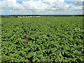
Potato crop, Thorner Moor
About 105 metres above sea level.
Image: © Christine Johnstone
Taken: 15 Aug 2023
0.15 miles
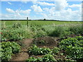
7
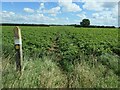
Waymarked footpath across a field of potatoes
This Thorner Moor path originally followed a field boundary, but that has disappeared and it is now cross-field.
Image: © Christine Johnstone
Taken: 15 Aug 2023
0.16 miles
8
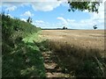
Field edge footpath, Thorner Moor
This footpath is shown on the large-scale OS map surveyed in 1845-47.
Image: © Christine Johnstone
Taken: 15 Aug 2023
0.19 miles
9
Footpath crossing from one potato field to another
On Thorner Moor, about 110 metres above sea level.
Image: © Christine Johnstone
Taken: 15 Aug 2023
0.20 miles