IMAGES TAKEN NEAR TO
Sandhills, LEEDS, LS14 3DN
Introduction
This page details the photographs taken nearby to Sandhills, LS14 3DN by members of the Geograph project.
The Geograph project started in 2005 with the aim of publishing, organising and preserving representative images for every square kilometre of Great Britain, Ireland and the Isle of Man.

There are currently over 7.5m images from over14,400 individuals and you can help contribute to the project by visiting https://www.geograph.org.uk
Image Map
Images are licensed for reuse under creativecommons.org/licenses/by-sa/2.0
Notes
- Clicking on the map will re-center to the selected point.
- The higher the marker number, the further away the image location is from the centre of the postcode.
Image Listing (13 Images Found)
Images are licensed for reuse under creativecommons.org/licenses/by-sa/2.0
Image
Details
Distance
1
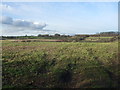
Field west of Thorner Lane
Farmland beside the road to Thorner.
Image: © DS Pugh
Taken: 3 Aug 2024
0.03 miles
4
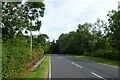
Thorner Lane near Mirycarr Lane
Thorner Lane heading north towards Thorner.
Image: © DS Pugh
Taken: 3 Aug 2024
0.11 miles
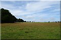
5
A walk from Oulton Church #64
Thorner and the end of today's walk. The 770 bus back into Leeds a pint and a little walk around Leeds before catching the 14-30 X62 bus back to Hull.
Image: © Ian S
Taken: 14 Aug 2010
0.12 miles
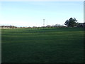
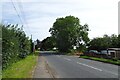
6
Lower Sandhills and Intake Lane
On the right is Intake Lane on the road south of Thorner.
Image: © DS Pugh
Taken: 3 Aug 2024
0.14 miles
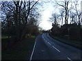
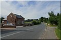
7
Lower Sandhill / Intake Lane bus stop
Lower Sandhill heading north towards Thorner.
Image: © DS Pugh
Taken: 3 Aug 2024
0.16 miles

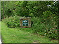
9
Mirycarr Lane (2)
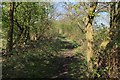
Public footpath between Thorner Lane and A64
Image: © Chris Heaton
Taken: 9 Apr 2017
0.20 miles