IMAGES TAKEN NEAR TO
Sandhill Villas, LEEDS, LS14 3DJ
Introduction
This page details the photographs taken nearby to Sandhill Villas, LS14 3DJ by members of the Geograph project.
The Geograph project started in 2005 with the aim of publishing, organising and preserving representative images for every square kilometre of Great Britain, Ireland and the Isle of Man.

There are currently over 7.5m images from over14,400 individuals and you can help contribute to the project by visiting https://www.geograph.org.uk
Image Map
Images are licensed for reuse under creativecommons.org/licenses/by-sa/2.0
Notes
- Clicking on the map will re-center to the selected point.
- The higher the marker number, the further away the image location is from the centre of the postcode.
Image Listing (13 Images Found)
Images are licensed for reuse under creativecommons.org/licenses/by-sa/2.0
Image
Details
Distance
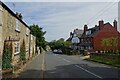
1
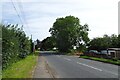
Lower Sandhill / Intake Lane bus stop
Lower Sandhill heading north towards Thorner.
Image: © DS Pugh
Taken: 3 Aug 2024
0.01 miles
2
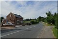
Lower Sandhills and Intake Lane
On the right is Intake Lane on the road south of Thorner.
Image: © DS Pugh
Taken: 3 Aug 2024
0.02 miles
3
Sandhill.
Looking NE towards Germaine Terrace.
Image: © Steve Partridge
Taken: 2 Sep 2006
0.09 miles
4
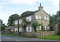
Pear Tree Cottage - Lower Sandhills
Image: © Betty Longbottom
Taken: 3 Sep 2008
0.09 miles
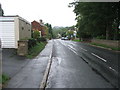
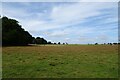
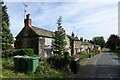
5
Houses along Lower Sandhills
The road heading towards Thorner.
Image: © DS Pugh
Taken: 3 Aug 2024
0.10 miles

8
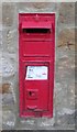
Victorian Post Box - Lower Sandhills
This is situated in the wall of Thorner Lodge.
Image: © Betty Longbottom
Taken: 3 Sep 2008
0.13 miles
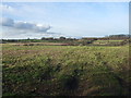
9
Field west of Thorner Lane
Farmland beside the road to Thorner.
Image: © DS Pugh
Taken: 3 Aug 2024
0.17 miles
10
Cottages along Lower Sandhills
The road heading towards Thorner.
Image: © DS Pugh
Taken: 3 Aug 2024
0.19 miles