IMAGES TAKEN NEAR TO
Syke Green, LEEDS, LS14 3BS
Introduction
This page details the photographs taken nearby to Syke Green, LS14 3BS by members of the Geograph project.
The Geograph project started in 2005 with the aim of publishing, organising and preserving representative images for every square kilometre of Great Britain, Ireland and the Isle of Man.

There are currently over 7.5m images from over14,400 individuals and you can help contribute to the project by visiting https://www.geograph.org.uk
Image Map
Images are licensed for reuse under creativecommons.org/licenses/by-sa/2.0
Notes
- Clicking on the map will re-center to the selected point.
- The higher the marker number, the further away the image location is from the centre of the postcode.
Image Listing (35 Images Found)
Images are licensed for reuse under creativecommons.org/licenses/by-sa/2.0
Image
Details
Distance
5
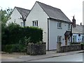
Double depth house, Syke Lane
This house in Scarcroft possibly once had an industrial function?
Image: © Christine Johnstone
Taken: 18 Jul 2012
0.09 miles
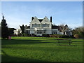
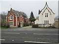
7
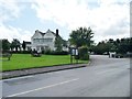
The New Inn, Scarcroft
'Country pub and dining' with extensive grounds.
Image: © Christine Johnstone
Taken: 18 Jul 2012
0.09 miles
8
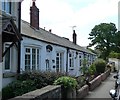
Four single storey cottages, Syke Lane
A bungalow terrace is unusual for West Yorkshire, except for older people's public housing, which this is not.
Image: © Christine Johnstone
Taken: 18 Jul 2012
0.09 miles