IMAGES TAKEN NEAR TO
Thorner Lane, LEEDS, LS14 3AQ
Introduction
This page details the photographs taken nearby to Thorner Lane, LS14 3AQ by members of the Geograph project.
The Geograph project started in 2005 with the aim of publishing, organising and preserving representative images for every square kilometre of Great Britain, Ireland and the Isle of Man.

There are currently over 7.5m images from over14,400 individuals and you can help contribute to the project by visiting https://www.geograph.org.uk
Image Map
Images are licensed for reuse under creativecommons.org/licenses/by-sa/2.0
Notes
- Clicking on the map will re-center to the selected point.
- The higher the marker number, the further away the image location is from the centre of the postcode.
Image Listing (23 Images Found)
Images are licensed for reuse under creativecommons.org/licenses/by-sa/2.0
Image
Details
Distance
1
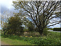
Junction of Thorner Lane and Milner Lane
The triangular junction surrounds a small pond with trees and flowers.
Image: © Stephen Craven
Taken: 17 Apr 2017
0.06 miles
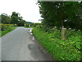
2
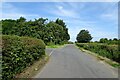
Milner Lane meets Thorner Lane
The road heading towards Rigton from Thorner.
Image: © DS Pugh
Taken: 3 Aug 2024
0.07 miles
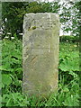
3
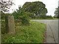
Old milestone
A view of the 19th century milestone at the triangle of roads, Milner Lane/Thorner Lane. It was re-set in 2002, then knocked over but re-set again. As the legend - hand to right/To Leeds/5 Mile(s) is now on the back face this is not the original way round for this stone. Both legends have become more eroded in the last 20 years. Grade II listsed 1265279.
Image: © Chris Minto
Taken: 8 Oct 2023
0.07 miles
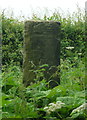
4
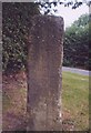
Old Milestone by Milner Lane, Scarcroft Parish
By the UC road, in the parish of Scarcroft (Leeds District), Milner Lane, junction with Thorner Lane, on grassy triangle.
East face inscribed: : To Wetherby 4 Miles :
West face (rear) roughly inscribed: : To Leeds (?) Miles :
Grade II Listed. List Entry Number: 1265279
https://historicengland.org.uk/listing/the-list/list-entry/1265279
Surveyed
Milestone Society National ID: YW_XSCARd.
Image: © Milestone Society
Taken: Unknown
0.07 miles
5
Milestone, Milner Lane, Scarcroft
See Image, Image and also http://www.thornerhistory.org.uk/wp-content/uploads/2016/03/ms-scarcroft-Ver4.pdf .
Image: © Humphrey Bolton
Taken: 10 Jun 2017
0.07 miles
6
Milestone, Milner Lane, Scarcroft
This stone is Grade II listed, and is on an old route from Leeds to Wetherby, used before the present A58 road was constructed as a turnpike road. On this side the Inscription is 'Wetherby 4 Miles, unfortunately not clear in my photograph. On the other side the inscription is 'Leeds 5 Miles'. The '5' appears to have been recut, and is not correct. This is discussed in http://www.thornerhistory.org.uk/wp-content/uploads/2016/03/ms-scarcroft-Ver4.pdf . It is not shown on the 1850 six-inch map, although a bench mark is shown here. The 1893 1:2500 map shows 'G.P.' and also the bench mark, which was no doubt on the stone although it does not seems to be visible now. Modern maps show it as a milestone, 'MS'.
Image: © Humphrey Bolton
Taken: 10 Jun 2017
0.07 miles
7
Back of milestone, Milner Lane, Scarcroft
See Image for the front of the stone and information.
Image: © Humphrey Bolton
Taken: 10 Jun 2017
0.07 miles
8
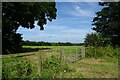
Field north of Thorner Lane
A field entrance on Milner Lane near the junction with Thorner Lane.
Image: © DS Pugh
Taken: 3 Aug 2024
0.10 miles
9
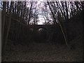
Bridge over dismantled railway
Thorner Lane runs across the bridge.
Image: © Chris McLean
Taken: 11 Dec 2005
0.13 miles
10
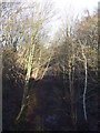
Course of disused railway
North of Thorner Lane.
Image: © JThomas
Taken: 14 Dec 2013
0.13 miles