IMAGES TAKEN NEAR TO
Thorner Lane, LEEDS, LS14 3AN
Introduction
This page details the photographs taken nearby to Thorner Lane, LS14 3AN by members of the Geograph project.
The Geograph project started in 2005 with the aim of publishing, organising and preserving representative images for every square kilometre of Great Britain, Ireland and the Isle of Man.

There are currently over 7.5m images from over14,400 individuals and you can help contribute to the project by visiting https://www.geograph.org.uk
Image Map
Images are licensed for reuse under creativecommons.org/licenses/by-sa/2.0
Notes
- Clicking on the map will re-center to the selected point.
- The higher the marker number, the further away the image location is from the centre of the postcode.
Image Listing (16 Images Found)
Images are licensed for reuse under creativecommons.org/licenses/by-sa/2.0
Image
Details
Distance
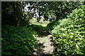
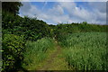
4
Plenty of weeds on the Leeds Country Way
Image: © John Slater
Taken: 4 Jul 2012
0.08 miles
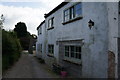
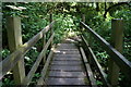
8
Thorner Lane
The lane between Scarcroft and Scarcroft Hill.
Image: © Chris Heaton
Taken: 15 Jul 2009
0.15 miles
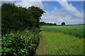
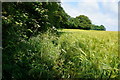
9
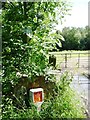
Advert for a mole catcher, Thorner Lane
In the bush above the gas pipeline marker, just north of the Scarcroft Beck bridge.
Image: © Christine Johnstone
Taken: 18 Jul 2012
0.18 miles
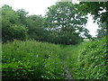
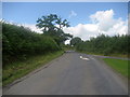
10
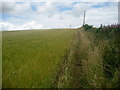
Leeds Country Way, Scarcroft
The long distance footpath follows the edge of this field, as it skirts to the east of Scarcroft village.
Image: © Chris Heaton
Taken: 15 Jul 2009
0.18 miles