IMAGES TAKEN NEAR TO
White Laithe Road, LEEDS, LS14 2DX
Introduction
This page details the photographs taken nearby to White Laithe Road, LS14 2DX by members of the Geograph project.
The Geograph project started in 2005 with the aim of publishing, organising and preserving representative images for every square kilometre of Great Britain, Ireland and the Isle of Man.

There are currently over 7.5m images from over14,400 individuals and you can help contribute to the project by visiting https://www.geograph.org.uk
Image Map
Images are licensed for reuse under creativecommons.org/licenses/by-sa/2.0
Notes
- Clicking on the map will re-center to the selected point.
- The higher the marker number, the further away the image location is from the centre of the postcode.
Image Listing (69 Images Found)
Images are licensed for reuse under creativecommons.org/licenses/by-sa/2.0
Image
Details
Distance
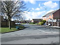
1
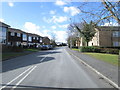
White Laithe Road - Sherburn Road North
Image: © Betty Longbottom
Taken: 23 Feb 2015
0.01 miles
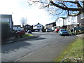
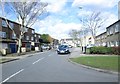
2
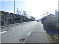
Sherburn Road North - viewed from White Laithe Road
Image: © Betty Longbottom
Taken: 23 Feb 2015
0.02 miles
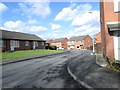
3
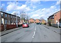
White Laithe Approach - viewed from White Laithe Road
Image: © Betty Longbottom
Taken: 23 Feb 2015
0.02 miles
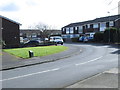
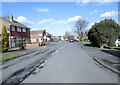
5
White Laithe Croft - White Laithe Approach
Image: © Betty Longbottom
Taken: 23 Feb 2015
0.05 miles
7
White Laithe Garth - White Laithe Croft
Image: © Betty Longbottom
Taken: 23 Feb 2015
0.06 miles
8
Hathaway Drive - White Laithe Road
Image: © Betty Longbottom
Taken: 23 Feb 2015
0.07 miles
9
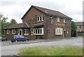
The Penda's Arms - Naburn Approach, Whinmoor
Penda was a King of Mercia who ruled c.626 to 655 AD.
Image: © Betty Longbottom
Taken: 22 Jul 2008
0.08 miles
10
Willow Garth Close - Willow Garth Avenue
Image: © Betty Longbottom
Taken: 23 Feb 2015
0.09 miles