IMAGES TAKEN NEAR TO
Ring Road, LEEDS, LS14 1NH
Introduction
This page details the photographs taken nearby to Ring Road, LS14 1NH by members of the Geograph project.
The Geograph project started in 2005 with the aim of publishing, organising and preserving representative images for every square kilometre of Great Britain, Ireland and the Isle of Man.

There are currently over 7.5m images from over14,400 individuals and you can help contribute to the project by visiting https://www.geograph.org.uk
Image Map
Images are licensed for reuse under creativecommons.org/licenses/by-sa/2.0
Notes
- Clicking on the map will re-center to the selected point.
- The higher the marker number, the further away the image location is from the centre of the postcode.
Image Listing (20 Images Found)
Images are licensed for reuse under creativecommons.org/licenses/by-sa/2.0
Image
Details
Distance
1
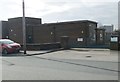
Electricity Substation No 2950 - Limewood Road
Image: © Betty Longbottom
Taken: 17 Feb 2015
0.11 miles
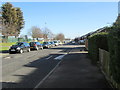
3
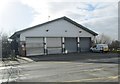
Ambulance Station - Ramshead Approach
Image: © Betty Longbottom
Taken: 17 Feb 2015
0.13 miles
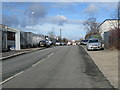
4
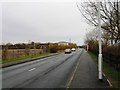
Ramshead Approach - Ring Road, Seacroft
Image: © Betty Longbottom
Taken: 17 Feb 2015
0.13 miles
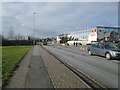
6

Limewood industrial estate (2)
Various buildings facing the old ring road across a wide strip of grass. These appear on maps as long ago as 1968.
Image: © Stephen Craven
Taken: 24 Feb 2024
0.16 miles
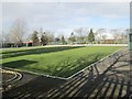
9

Bowls Pavilion - Whinmoor Bowling Club - Hebden Approach
Image: © Betty Longbottom
Taken: 17 Feb 2015
0.19 miles
10
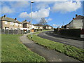
Eastdean Grove - viewed from Eastdean Rise
Image: © Betty Longbottom
Taken: 17 Feb 2015
0.21 miles