IMAGES TAKEN NEAR TO
Boggart Hill Road, LEEDS, LS14 1LB
Introduction
This page details the photographs taken nearby to Boggart Hill Road, LS14 1LB by members of the Geograph project.
The Geograph project started in 2005 with the aim of publishing, organising and preserving representative images for every square kilometre of Great Britain, Ireland and the Isle of Man.

There are currently over 7.5m images from over14,400 individuals and you can help contribute to the project by visiting https://www.geograph.org.uk
Image Map
Images are licensed for reuse under creativecommons.org/licenses/by-sa/2.0
Notes
- Clicking on the map will re-center to the selected point.
- The higher the marker number, the further away the image location is from the centre of the postcode.
Image Listing (51 Images Found)
Images are licensed for reuse under creativecommons.org/licenses/by-sa/2.0
Image
Details
Distance
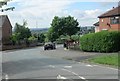
2
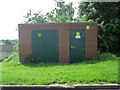
Electricity Substation No 2176 - Boggart Hill Road
Image: © Betty Longbottom
Taken: 26 May 2014
0.03 miles
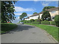
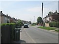
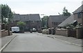
3
Boggart Hill Crescent - Boggart Hill Drive
Image: © Betty Longbottom
Taken: 19 May 2014
0.06 miles
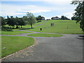
6
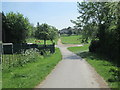
Footpath across Rein Park - viewed from Boggart Hill Drive
Image: © Betty Longbottom
Taken: 19 May 2014
0.08 miles
7
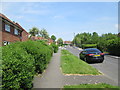
Barncroft Rise - Boggart Hill Drive
Image: © Betty Longbottom
Taken: 19 May 2014
0.09 miles
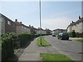
8
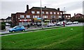
Parade of shops, Boggart Hill Drive
At the 89 metre spot height.
Image: © Christine Johnstone
Taken: 21 Nov 2012
0.10 miles
9
Boggart Hill Gardens - Boggart Hill Road
Image: © Betty Longbottom
Taken: 26 May 2014
0.10 miles
10
Beechwood Court - Boggart Hill Gardens
Image: © Betty Longbottom
Taken: 26 May 2014
0.11 miles