IMAGES TAKEN NEAR TO
Barncroft Towers, LEEDS, LS14 1HR
Introduction
This page details the photographs taken nearby to Barncroft Towers, LS14 1HR by members of the Geograph project.
The Geograph project started in 2005 with the aim of publishing, organising and preserving representative images for every square kilometre of Great Britain, Ireland and the Isle of Man.

There are currently over 7.5m images from over14,400 individuals and you can help contribute to the project by visiting https://www.geograph.org.uk
Image Map
Images are licensed for reuse under creativecommons.org/licenses/by-sa/2.0
Notes
- Clicking on the map will re-center to the selected point.
- The higher the marker number, the further away the image location is from the centre of the postcode.
Image Listing (43 Images Found)
Images are licensed for reuse under creativecommons.org/licenses/by-sa/2.0
Image
Details
Distance
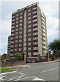
1
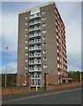
Barncroft Towers - Barncroft Drive
Image: © Betty Longbottom
Taken: 26 May 2014
0.01 miles
2
Barncroft Drive - Boggart Hill Drive
Image: © Betty Longbottom
Taken: 26 May 2014
0.03 miles
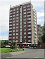
3
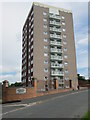
Barncroft Heights - Barncroft Drive
Image: © Betty Longbottom
Taken: 26 May 2014
0.04 miles
5
Barncroft Grange - Boggart Hill Drive
Image: © Betty Longbottom
Taken: 26 May 2014
0.05 miles
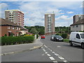
6
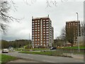
Barncroft tower blocks, Monkswood
The block in the centre is Barncroft Court. Behind is Barncroft Towers and to the right Barncroft Grange. There is also Barncroft Heights, not visible in this view. The four blocks are each 12 storeys high and were constructed c.1961.
Image: © Stephen Craven
Taken: 26 Mar 2023
0.06 miles
7
Barncroft Court - Boggart Hill Drive
Image: © Betty Longbottom
Taken: 26 May 2014
0.07 miles
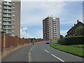
8
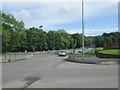
Easterly Road - viewed from Boggart Hill Drive
Image: © Betty Longbottom
Taken: 26 May 2014
0.08 miles
9
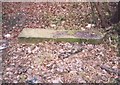
Old Milestone by the A58, Easterly Road, Leeds parish
WR iron casting by the A58, in parish of Leeds (Leeds District), Easterly Road, just North of end of dual carriageway, near Boggart Hill Road and Wetherby Road, near lamppost 56 under trees and bushes.
Lost since 2000.
Inscription once read:-
: (Weatherby 8½) : : (Leeds / 4) :
Milestone Society National ID: YW_LECM04
Image: © Milestone Society
Taken: Unknown
0.08 miles
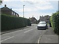
10
Boggart Hill Road - viewed from Boggart Hill
Image: © Betty Longbottom
Taken: 26 May 2014
0.08 miles