IMAGES TAKEN NEAR TO
Hindwell Grove, LEEDS, LS14 1FW
Introduction
This page details the photographs taken nearby to Hindwell Grove, LS14 1FW by members of the Geograph project.
The Geograph project started in 2005 with the aim of publishing, organising and preserving representative images for every square kilometre of Great Britain, Ireland and the Isle of Man.

There are currently over 7.5m images from over14,400 individuals and you can help contribute to the project by visiting https://www.geograph.org.uk
Image Map
Images are licensed for reuse under creativecommons.org/licenses/by-sa/2.0
Notes
- Clicking on the map will re-center to the selected point.
- The higher the marker number, the further away the image location is from the centre of the postcode.
Image Listing (32 Images Found)
Images are licensed for reuse under creativecommons.org/licenses/by-sa/2.0
Image
Details
Distance
1
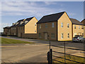
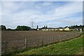
Bramley Gardens
A recent development on the edge of Whinmoor, probably to be followed by further infill development out to the new orbital road in coming years.
Image: © Stephen Craven
Taken: 26 Aug 2022
0.04 miles
2
New housing on Skeltons Lane
These new houses on the edge of the built up area of Leeds are probably a good investment as the ELOR (East Leeds Orbital Road) will be built nearby in the next few years. At the time of submission, Open Street Map named this development as Bramley Gardens, the developer (Arncliffe Homes) calls it Bramley Grange but there was a different road name sign on site (unfortunately I can't recall it).
Image: © Stephen Craven
Taken: 14 Sep 2019
0.05 miles
3
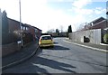
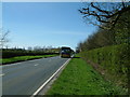
Bus stop on Skeltons Lane
Passengers had just alighted for the new housing development Image The bus was displaying route 7 to Wetherby, but was actually heading from Harrogate to Leeds.
This scene will change as a junction with the new ELOR (East Leeds Orbital Road) is built 300 metres further along the road in the next few years.
Image: © Stephen Craven
Taken: 14 Sep 2019
0.07 miles
4
Bramley Gardens
Looking towards new houses alongside the East Leeds Orbital Route.
Image: © DS Pugh
Taken: 3 Aug 2024
0.10 miles
5
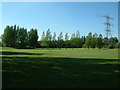
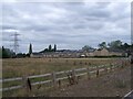
Small games field on the outskirts of Whinmoor
Image: © Leslie
Taken: 9 Sep 2006
0.11 miles
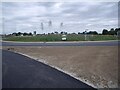
6
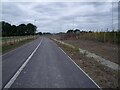
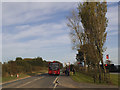
Cycleway north of Skeltons Lane roundabout
At this point the cycle lane is set below the level of the main road, and will be separate from it by a belt of trees once they have grown.
The photo is taken (as accurately as I can tell) from the location of Bramley Grange farmhouse that was demolished to make way for the new road Image
Image: © Stephen Craven
Taken: 26 Aug 2022
0.12 miles
7
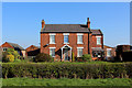
Bramley Grange Farm
Farm on Skeltons Lane, Whinmoor
Image: © Chris Heaton
Taken: 9 Apr 2017
0.12 miles
8
770 to Harrogate on Skeltons Lane approaching Bramley Grange
Image: © Leslie
Taken: 7 Apr 2011
0.12 miles
9
Skeltons Lane roundabout on the ELOR
Image: © Stephen Craven
Taken: 26 Aug 2022
0.15 miles