IMAGES TAKEN NEAR TO
Ramshead Hill, LEEDS, LS14 1BT
Introduction
This page details the photographs taken nearby to Ramshead Hill, LS14 1BT by members of the Geograph project.
The Geograph project started in 2005 with the aim of publishing, organising and preserving representative images for every square kilometre of Great Britain, Ireland and the Isle of Man.

There are currently over 7.5m images from over14,400 individuals and you can help contribute to the project by visiting https://www.geograph.org.uk
Image Map
Images are licensed for reuse under creativecommons.org/licenses/by-sa/2.0
Notes
- Clicking on the map will re-center to the selected point.
- The higher the marker number, the further away the image location is from the centre of the postcode.
Image Listing (50 Images Found)
Images are licensed for reuse under creativecommons.org/licenses/by-sa/2.0
Image
Details
Distance
2
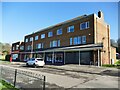
Shops on Kentmere Avenue
Including a post office, with postbox outside.
Image: © Stephen Craven
Taken: 24 Feb 2024
0.05 miles
3
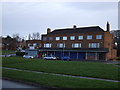
Shops off Kentmere Avenue
One on the left is a Post Office.
Image: © JThomas
Taken: 14 Dec 2013
0.05 miles
4
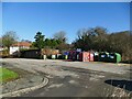
Recyling facilities behind the shops on Kentmere Avenue
Note also the lockup garages.
Image: © Stephen Craven
Taken: 24 Feb 2024
0.05 miles
5
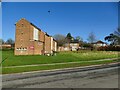
St Richard's, Seacroft: east side
A good example of a post-war estate church, St Richard’s was built from 1955, being dedicated by the Bishop of Ripon on 12th December 1956. Unusually for the time, there is a crypt. The dedication is to a lesser-known British saint, Richard of Chichester. as the first priest-in-charge had been Vice-Principal of Chichester Theological College. Re-ordered in the 1970s as a dual purpose building and again in 1995. The church is built in an almost north-south direction rather than the conventional west-east, and its axis is pretty much along the OS gridline. It is a Licensed Place of Worship within the Parish of Seacroft, where St James's is the parish church, along with a congregation meetign in a school. Two other Anglican churches within the parish, Swarcliffe St Luke and the Church of the Ascension, have closed within the last twenty years. [Information mainly from the parish website].
Image: © Stephen Craven
Taken: 24 Feb 2024
0.05 miles
6
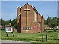
St Richard's Church - viewed from Ramshead Hill
Image: © Betty Longbottom
Taken: 19 May 2014
0.05 miles
7
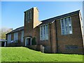
St Richard's, Seacroft: west side
A good example of a post-war estate church, St Richard’s was built from 1955, being dedicated by the Bishop of Ripon on 12th December 1956. Unusually for the time, there is a crypt. The dedication is to a lesser-known British saint, Richard of Chichester. as the first priest-in-charge had been Vice-Principal of Chichester Theological College. Re-ordered in the 1970s as a dual purpose building and again in 1995. The church is built in an almost north-south direction rather than the conventional west-east, and its axis is pretty much along the OS gridline. It is a Licensed Place of Worship within the Parish of Seacroft, where St James's is the parish church, along with a congregation meetign in a school. Two other Anglican churches within the parish, Swarcliffe St Luke and the Church of the Ascension, have closed within the last twenty years. [Information mainly from the parish website].
Image: © Stephen Craven
Taken: 24 Feb 2024
0.05 miles
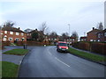
9
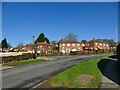
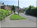
Ramshead Gardens
Part of a post-war housing development.
Image: © Stephen Craven
Taken: 24 Feb 2024
0.06 miles
10
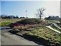
Steps from Kentmere Avenue to Ramshead Drive
The path connects two otherwise poorly connected housing estates.
Image: © Stephen Craven
Taken: 24 Feb 2024
0.07 miles