IMAGES TAKEN NEAR TO
Ringwood Drive, LEEDS, LS14 1AP
Introduction
This page details the photographs taken nearby to Ringwood Drive, LS14 1AP by members of the Geograph project.
The Geograph project started in 2005 with the aim of publishing, organising and preserving representative images for every square kilometre of Great Britain, Ireland and the Isle of Man.

There are currently over 7.5m images from over14,400 individuals and you can help contribute to the project by visiting https://www.geograph.org.uk
Image Map
Images are licensed for reuse under creativecommons.org/licenses/by-sa/2.0
Notes
- Clicking on the map will re-center to the selected point.
- The higher the marker number, the further away the image location is from the centre of the postcode.
Image Listing (54 Images Found)
Images are licensed for reuse under creativecommons.org/licenses/by-sa/2.0
Image
Details
Distance
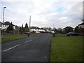
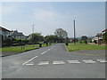
1
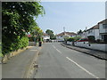
Ringwood Drive - Ring Road, Seacroft
Image: © Betty Longbottom
Taken: 19 May 2014
0.07 miles
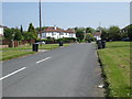
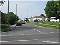
2
Ringwood Drive - viewed from Ringwood Avenue
Image: © Betty Longbottom
Taken: 19 May 2014
0.07 miles
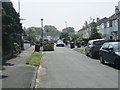
3
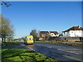
Old Ring Road, Seacroft
Formerly the A6120, now the B6902. The ambulance was on an emergency call.
Image: © Stephen Craven
Taken: 24 Feb 2024
0.08 miles
4
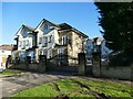
Bluebell Court, Seacroft
Private apartments situated on the Old Ring Road.
Image: © Stephen Craven
Taken: 24 Feb 2024
0.08 miles
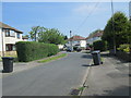
5
Ringwood Gardens - Ringwood Avenue
Image: © Betty Longbottom
Taken: 19 May 2014
0.09 miles
6
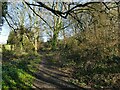
Path into Hawthorn Park
OpenStreetMap names it as Hawthron Park but I take this to be a typo.
Image: © Stephen Craven
Taken: 24 Feb 2024
0.09 miles
8
Monkswood Gate - Ring Road, Seacroft
Image: © Betty Longbottom
Taken: 19 May 2014
0.09 miles