IMAGES TAKEN NEAR TO
Wellstone Garth, LEEDS, LS13 4HL
Introduction
This page details the photographs taken nearby to Wellstone Garth, LS13 4HL by members of the Geograph project.
The Geograph project started in 2005 with the aim of publishing, organising and preserving representative images for every square kilometre of Great Britain, Ireland and the Isle of Man.

There are currently over 7.5m images from over14,400 individuals and you can help contribute to the project by visiting https://www.geograph.org.uk
Image Map
Images are licensed for reuse under creativecommons.org/licenses/by-sa/2.0
Notes
- Clicking on the map will re-center to the selected point.
- The higher the marker number, the further away the image location is from the centre of the postcode.
Image Listing (111 Images Found)
Images are licensed for reuse under creativecommons.org/licenses/by-sa/2.0
Image
Details
Distance
1
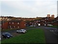
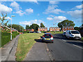
Wellstone Garth, Swinnow Moor
Part of a post-War estate; immediately beyond the houses to the right of the photo were the Park Quarries, an area that remains undeveloped for housing to this day.
Image: © Stephen Craven
Taken: 10 Jan 2016
0.02 miles
2
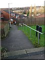
Wellstone Garth steps
This path and its steps provide a short cut between the upper and lower parts of the road Image
Image: © Stephen Craven
Taken: 10 Jan 2016
0.03 miles
3
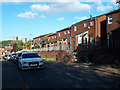
Wellstone Garth
There is a variety of housing styles on this estate, compare Image
Image: © Stephen Craven
Taken: 24 May 2020
0.03 miles
4
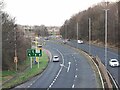
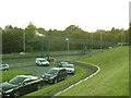
CCTV on Stanningley Bypass
This section of the Leeds Ring Road was reduced during 2023 from 60mph to 50mph, with additional average-speed cameras to enforce it.
Image: © Stephen Craven
Taken: 17 Dec 2023
0.06 miles
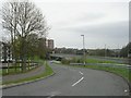
5
Wellstone Avenue
There is a generous verge between the curve of this road and the rows of houses set back from it.
Image: © Stephen Craven
Taken: 24 May 2020
0.07 miles
6
Slip Road to Bypass - off Spring Valley Crescent
Image: © Betty Longbottom
Taken: 4 Apr 2011
0.07 miles
7
Spring Valley Crescent, Bramley, Leeds
Image: © Mark Stevenson
Taken: 11 Oct 2017
0.08 miles
8
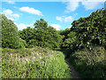
Path through Ducky Hills
The name 'Ducky Hills' is shown on some maps for this small area of scrubland, but I don't know whether that is the name used locally.
Image: © Stephen Craven
Taken: 24 May 2020
0.08 miles
9
Spring Valley Crescent, Swinnow, Leeds
Image: © Mark Stevenson
Taken: 25 Jan 2016
0.09 miles
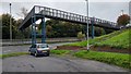
10
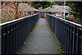
Footbridge over the Stanningley Bypass (1)
The route of this road (previously called the Bramley Ring Road) dates back to before World War 2, but the present dual carriageway was built c.1968. The footbridge connects the newer Spring Valley estate on the north (Bramley) side of the valley to older housing on the south (Swinnow) side. See also Image
Image: © Stephen Craven
Taken: 27 Aug 2015
0.09 miles