IMAGES TAKEN NEAR TO
Park Spring Rise, LEEDS, LS13 4DX
Introduction
This page details the photographs taken nearby to Park Spring Rise, LS13 4DX by members of the Geograph project.
The Geograph project started in 2005 with the aim of publishing, organising and preserving representative images for every square kilometre of Great Britain, Ireland and the Isle of Man.

There are currently over 7.5m images from over14,400 individuals and you can help contribute to the project by visiting https://www.geograph.org.uk
Image Map
Images are licensed for reuse under creativecommons.org/licenses/by-sa/2.0
Notes
- Clicking on the map will re-center to the selected point.
- The higher the marker number, the further away the image location is from the centre of the postcode.
Image Listing (197 Images Found)
Images are licensed for reuse under creativecommons.org/licenses/by-sa/2.0
Image
Details
Distance
1
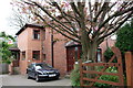
#7 Park Spring Rise
There is an OS benchmark Image on the left hand side of the house at its front corner, left of the brown door
Image: © Roger Templeman
Taken: 11 Apr 2017
0.01 miles
2
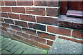
Benchmark on #7 Park Spring Rise
Ordnance Survey cut mark benchmark described on the Bench Mark Database at http://www.bench-marks.org.uk/bm83679
Image: © Roger Templeman
Taken: 11 Apr 2017
0.02 miles
3
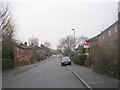
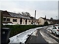
Park Spring Rise - looking towards Wellstone Avenue
Image: © Betty Longbottom
Taken: 17 Jan 2011
0.02 miles
4
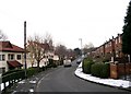
Park Spring Gardens - Park Spring Rise
Image: © Betty Longbottom
Taken: 17 Jan 2011
0.04 miles
5
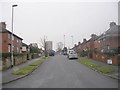
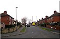
Housing on Wellstone Garth
The three blocks of flats on the left, according to an estate agent's website, were built in 1993 and are leasehold properties, but by comparison with the 1965 map they replaced earlier buildings on the same site.
It seems I was lucky to get to the end of this street unscathed, as according to the Yorkshire Evening Post this was sixth on its list of "Leeds streets with the most violent crimes in 2020" according to data from West Yorkshire Police - nine assaults in July alone, although I expect most if not all of these would be of a domestic nature. I only saw a family getting out of a taxi and some children sledging on a bit of open ground.
Image: © Stephen Craven
Taken: 16 Jan 2021
0.04 miles
6
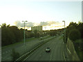
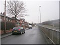
Stanningley Bypass at Spring Valley
The route of this road (previously called the Bramley Ring Road) dates back to before World War 2, but the present dual carriageway was built c.1968. The view is from the footbridge Image looking west to the slip road up to Swinnow Road junction.
Image: © Stephen Craven
Taken: 27 Aug 2015
0.05 miles
7
Wellstone Garth - Wellstone Avenue
Image: © Betty Longbottom
Taken: 12 Feb 2009
0.05 miles
8
Park Spring Gardens - Park Spring Rise - as snow begins to fall
Image: © Betty Longbottom
Taken: 12 Feb 2009
0.05 miles
9
Park Spring Gardens - looking towards Swinnow Road
Image: © Betty Longbottom
Taken: 17 Jan 2011
0.06 miles
10

Park Spring Rise - Wellstone Avenue
Image: © Betty Longbottom
Taken: 12 Feb 2009
0.06 miles