IMAGES TAKEN NEAR TO
Henconner Lane, LEEDS, LS13 4AQ
Introduction
This page details the photographs taken nearby to Henconner Lane, LS13 4AQ by members of the Geograph project.
The Geograph project started in 2005 with the aim of publishing, organising and preserving representative images for every square kilometre of Great Britain, Ireland and the Isle of Man.

There are currently over 7.5m images from over14,400 individuals and you can help contribute to the project by visiting https://www.geograph.org.uk
Image Map
Images are licensed for reuse under creativecommons.org/licenses/by-sa/2.0
Notes
- Clicking on the map will re-center to the selected point.
- The higher the marker number, the further away the image location is from the centre of the postcode.
Image Listing (251 Images Found)
Images are licensed for reuse under creativecommons.org/licenses/by-sa/2.0
Image
Details
Distance
1
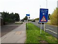
Bridge warning sign at Town End
The railway bridge on Henconner Lane Image has had a number of strikes by large vehicles over the years.
Image: © Stephen Craven
Taken: 18 Oct 2023
0.02 miles
2
Westbound exit slip road at Town End
Two traffic lanes leaving the Stanningley Bypass - left for Henconner Lane and St Mary's Hospital, right for Town End roundabout and the A647 / A657.
Image: © Stephen Craven
Taken: 18 Oct 2023
0.02 miles
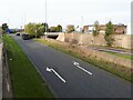
3
Tiger Crossing, Henconner Lane, Bramley
A tiger crossing is a signalled cycle-only crossing. Here, the Leeds-Bradford Cycle Superhighway comes up alongside the slip road off the A647; if a cyclist presses the button below the lights shown here, when the traffic lights for the slip road go to green for right-turning traffic, left-turning traffic is delayed while cyclists are given time to cross to the cycle lane on the far side of the bridge.
Image: © Stephen Craven
Taken: 18 Apr 2020
0.03 miles
4
Water installation at the top of Henconner Lane
Several large covers indicate the presence of valves or other equipment beneath the pavement, as well as the control cabinet.
Image: © Stephen Craven
Taken: 1 Nov 2020
0.03 miles
5
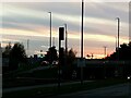
The Stanningley bypass at dusk
My phone camera didn't do justice to the red sunset, even with a bit of contrast adjustment.
Image: © Stephen Craven
Taken: 11 Feb 2021
0.03 miles
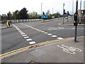
6
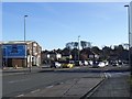
A657 crossing the Stanningley Bypass
Photographed before Leeds City Council started work on altering this junction and the nearby Town End roundabout as part of the City Connect cycleway scheme.
Image: © Stephen Craven
Taken: 21 Nov 2015
0.03 miles
7
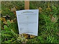
A not very public notice
The planning notice is (or was?) for the erection of three 8-metre telecommunications poles by Outreach. The notice is undated, the contact details are not filled in, and it was displayed at ground level on the grass verge of a slip road on the bypass where it would be totally unnoticed by motorists and passed by few pedestrians. Just possibly Outreach was hoping no-one would see it?
Image: © Stephen Craven
Taken: 1 Nov 2020
0.03 miles
8
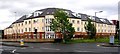
The Elms - Henconner Lane
This is a new development of 72 flats.
Image: © Betty Longbottom
Taken: 14 May 2007
0.04 miles
9
Green Hill Place - Green Hill Lane
Image: © Betty Longbottom
Taken: 29 Apr 2011
0.04 miles
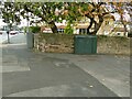
10
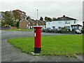
Postbox at the end of Green Hill Mount
A standard E II R pillar box.
Image: © Stephen Craven
Taken: 1 Nov 2020
0.04 miles