IMAGES TAKEN NEAR TO
The Old Orchard, LEEDS, LS13 3SW
Introduction
This page details the photographs taken nearby to The Old Orchard, LS13 3SW by members of the Geograph project.
The Geograph project started in 2005 with the aim of publishing, organising and preserving representative images for every square kilometre of Great Britain, Ireland and the Isle of Man.

There are currently over 7.5m images from over14,400 individuals and you can help contribute to the project by visiting https://www.geograph.org.uk
Image Map
Images are licensed for reuse under creativecommons.org/licenses/by-sa/2.0
Notes
- Clicking on the map will re-center to the selected point.
- The higher the marker number, the further away the image location is from the centre of the postcode.
Image Listing (211 Images Found)
Images are licensed for reuse under creativecommons.org/licenses/by-sa/2.0
Image
Details
Distance
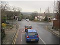
1
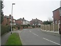
Cambridge Gardens - Leeds & Bradford Road
Image: © Betty Longbottom
Taken: 7 Mar 2011
0.04 miles
4
Cambridge House, Calverley Lane, Bramley
This large house (probably now two properties) was here on the 1893 map, when what is now called Calverley Lane was labelled as Whitecote Hill Lane.
Image: © Stephen Craven
Taken: 7 May 2021
0.05 miles
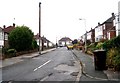
5
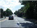
Leeds and Bradford Road at Whitecote Hill
Image: © Colin Pyle
Taken: 5 Jul 2014
0.06 miles
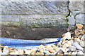
6
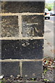
Benchmark on West Royd Lodge, Rodley Lane
Ordnance Survey cut mark benchmark described on the Bench Mark Database at https://www.bench-marks.org.uk/bm68690
Image: © Roger Templeman
Taken: 18 Apr 2017
0.06 miles
7
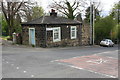
West Royd Lodge at junction of Leeds and Bradford Road and Upper Rodley Lane
There is an OS benchmark Image on the near corner, left hand face, of the lodge
Image: © Roger Templeman
Taken: 18 Apr 2017
0.06 miles
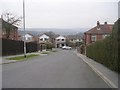
8
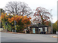
Junction of Upper Rodley Lane and Leeds and Bradford Road
The house on the opposite corner is West Royds Lodge. West Royds is the house with solar panels glimpsed behind it Image
Image: © Stephen Craven
Taken: 3 Nov 2019
0.06 miles
9
Road junction A657/B6157
A657 Whitecote Hill (foreground) crosses B6157 (Leeds and Bradford Road).
Taken from the top deck of the 86 bus to Rodley.
Image: © Stephen Craven
Taken: 16 Jan 2016
0.06 miles
10
Benchmark on #52 Whitecote Hill
Ordnance Survey cut mark benchmark described on the Bench Mark Database at https://www.bench-marks.org.uk/bm83903
Image: © Roger Templeman
Taken: 18 Apr 2017
0.07 miles