IMAGES TAKEN NEAR TO
Broadlea Street, LEEDS, LS13 2SB
Introduction
This page details the photographs taken nearby to Broadlea Street, LS13 2SB by members of the Geograph project.
The Geograph project started in 2005 with the aim of publishing, organising and preserving representative images for every square kilometre of Great Britain, Ireland and the Isle of Man.

There are currently over 7.5m images from over14,400 individuals and you can help contribute to the project by visiting https://www.geograph.org.uk
Image Map
Images are licensed for reuse under creativecommons.org/licenses/by-sa/2.0
Notes
- Clicking on the map will re-center to the selected point.
- The higher the marker number, the further away the image location is from the centre of the postcode.
Image Listing (201 Images Found)
Images are licensed for reuse under creativecommons.org/licenses/by-sa/2.0
Image
Details
Distance
1
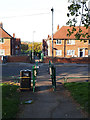
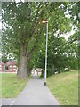
Path crossing Broadlea Street
A path runs through the middle of the Broadlea housing estate, ending at the bus stops on Leeds and Bradford Road. See also Image
Image: © Stephen Craven
Taken: 21 Apr 2020
0.04 miles
2
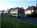
Bus on Broadlea Terrace
The 49 bus to Bramley serves the Broadlea housing estate, taking a circuitous route around it. Buses were still running during the 2020 Covid-19 shutdown, though at roughly half the usual frequency, and with hardly any passengers.
Image: © Stephen Craven
Taken: 21 Apr 2020
0.04 miles
4
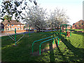
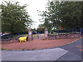
Open space on Broadlea Road: exercise facilities
At the heart of the Broadlea housing estate is a generously sized open space of 1.4 hectares, including these exercise facilities (not the more recent "outdoor gym" type, but an older style with parallel bars at waist height and overhead).
Image: © Stephen Craven
Taken: 21 Apr 2020
0.05 miles
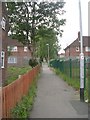
5
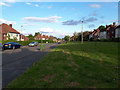
Longer green space on Broadlea Terrace
The largest of three such areas of grass alongside this road, from the days when housing estates were planned with public spaces.
Image: © Stephen Craven
Taken: 4 May 2020
0.05 miles
6
Open space on Broadlea Road: picnic and football
At the heart of the Broadlea housing estate is a generously sized open space of 1.4 hectares, including these picnic tables and benches, and a small (5-a-side size) football pitch seen in the background.
Image: © Stephen Craven
Taken: 21 Apr 2020
0.05 miles
7
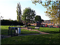
Pocket Park on Broadlea Road
The small fenced park is in the angle between Broadlea Road and Broadlea Street.
Image: © Stephen Craven
Taken: 13 Aug 2020
0.06 miles
9
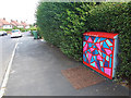
Utility cabinet with geometric pattern
This cabinet is on Broadlea Terrace at its western end.
Image: © Stephen Craven
Taken: 9 Aug 2020
0.06 miles
10
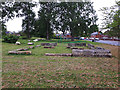
Green space above Broadlea Street: old stones
The 1968 map shows houses here, but now it is part of a green space stretching up to the other side of Broadlea Road. The stones here appear to have bee used in building at one time, and may be intended as a reminder of previous buildings on the site.
Image: © Stephen Craven
Taken: 10 May 2020
0.06 miles