IMAGES TAKEN NEAR TO
Musgrave View, LEEDS, LS13 2QN
Introduction
This page details the photographs taken nearby to Musgrave View, LS13 2QN by members of the Geograph project.
The Geograph project started in 2005 with the aim of publishing, organising and preserving representative images for every square kilometre of Great Britain, Ireland and the Isle of Man.

There are currently over 7.5m images from over14,400 individuals and you can help contribute to the project by visiting https://www.geograph.org.uk
Image Map
Images are licensed for reuse under creativecommons.org/licenses/by-sa/2.0
Notes
- Clicking on the map will re-center to the selected point.
- The higher the marker number, the further away the image location is from the centre of the postcode.
Image Listing (277 Images Found)
Images are licensed for reuse under creativecommons.org/licenses/by-sa/2.0
Image
Details
Distance
1
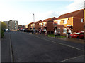
Houses on Musgrave View
Evening sunshine adds interest to the view of these otherwise undistinguished semis.
Image: © Stephen Craven
Taken: 3 Apr 2020
0.03 miles
2
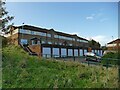
Integral garages on Musgrave View
Unlike many of the lock-up garages I have photographed this year (see shared description) these are integral to the relatively modern housing behind, so are not at risk of redevelopment.
Image: © Stephen Craven
Taken: 1 Nov 2020
0.03 miles
3
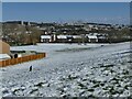
Snowy scene from Musgrave View
This vantage point offers a good view across the Aire Valley towards Burley, and a bit of snow adds something to the scene.
Image: © Stephen Craven
Taken: 10 Mar 2023
0.04 miles
5
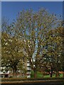
Ash tree on Musgrave View
Many of the leaves had been blown away by a stormy week at the end of October leaving the bunches of seed pods at the end of each branch more clearly visible.
Image: © Stephen Craven
Taken: 1 Nov 2020
0.04 miles
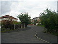
6
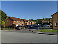
Raynville Place, Bramley
A small side road off Raynville Road, later than housing on the other side. Raynville Road itself had just been resurfaced.
Image: © Stephen Craven
Taken: 7 May 2020
0.06 miles
7
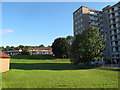
Open space off Raynville Road, Bramley
This land may never have been built on, since maps from before the construction of the present housing estates show it was farmland.
Image: © Stephen Craven
Taken: 30 Jul 2015
0.07 miles
8
Houghley Gill in spring
The Council had been through recently cutting a strip of grass either side of the path to prevent it getting overgrown, but leaving the remainder for wildflowers. Compare a late summer view Image
Image: © Stephen Craven
Taken: 22 May 2016
0.07 miles
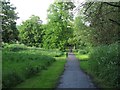
9

Path through Houghley Gill
The gill is steep sided and wooded; a well surfaced and lit public footpath runs through it. See also Image
Image: © Stephen Craven
Taken: 2 Aug 2015
0.07 miles
10
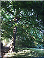
Under the spreading oak tree
A mature oak alongside the path in Houghley Gill, with a wide open canopy.
Image: © Stephen Craven
Taken: 31 May 2020
0.07 miles