IMAGES TAKEN NEAR TO
Musgrave Bank, LEEDS, LS13 2QJ
Introduction
This page details the photographs taken nearby to Musgrave Bank, LS13 2QJ by members of the Geograph project.
The Geograph project started in 2005 with the aim of publishing, organising and preserving representative images for every square kilometre of Great Britain, Ireland and the Isle of Man.

There are currently over 7.5m images from over14,400 individuals and you can help contribute to the project by visiting https://www.geograph.org.uk
Image Map
Images are licensed for reuse under creativecommons.org/licenses/by-sa/2.0
Notes
- Clicking on the map will re-center to the selected point.
- The higher the marker number, the further away the image location is from the centre of the postcode.
Image Listing (269 Images Found)
Images are licensed for reuse under creativecommons.org/licenses/by-sa/2.0
Image
Details
Distance
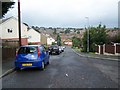
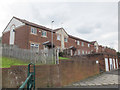
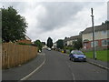
2
Houses on Musgrave Bank
The houses are set at an angle to the road in order to follow the contours of the hillside.
Image: © Stephen Craven
Taken: 2 Aug 2015
0.02 miles
3
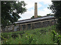
Chimney at Hilltop Commercial Centre (1)
The chimney itself is probably disused but remains at the heart of a small industrial estate on the edge of Bramley.
Image: © Stephen Craven
Taken: 2 Aug 2015
0.04 miles
4
Chimney at Hilltop Commercial Centre (2)
The chimney itself is probably disused but remains at the heart of a small industrial estate on the edge of Bramley.
Image: © Stephen Craven
Taken: 2 Aug 2015
0.04 miles
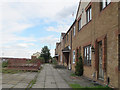
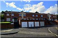
5
Houses on Musgrave Mount
The houses are set at an angle to the road in order to follow the contours of the hillside.
Image: © Stephen Craven
Taken: 2 Aug 2015
0.04 miles
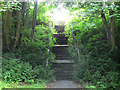
7
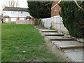
Steps, Musgrave Bank, Bramley
The steps are the start of a pedestrian shortcut from the Raynville estate to the Aston estate (the only vehicular route is via Snowden Crescent some distance away).
Image: © Stephen Craven
Taken: 3 Apr 2020
0.06 miles
8
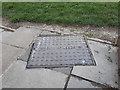
City of Leeds manhole cover, Musgrave Bank, Bramley
Local authorities in West Yorkshire were responsible for sewerage in their area before about 1986 when Yorkshire Water took over. This cover is set obliquely into a flight of steps Image
Image: © Stephen Craven
Taken: 3 Apr 2020
0.06 miles
10
Steps from Houghley Gill to Musgrave Mount
One of many paths connecting residential streets in this hilly area of Leeds.
Image: © Stephen Craven
Taken: 2 Aug 2015
0.06 miles