IMAGES TAKEN NEAR TO
Whitecote Hill, LEEDS, LS13 2HU
Introduction
This page details the photographs taken nearby to Whitecote Hill, LS13 2HU by members of the Geograph project.
The Geograph project started in 2005 with the aim of publishing, organising and preserving representative images for every square kilometre of Great Britain, Ireland and the Isle of Man.

There are currently over 7.5m images from over14,400 individuals and you can help contribute to the project by visiting https://www.geograph.org.uk
Image Map
Images are licensed for reuse under creativecommons.org/licenses/by-sa/2.0
Notes
- Clicking on the map will re-center to the selected point.
- The higher the marker number, the further away the image location is from the centre of the postcode.
Image Listing (296 Images Found)
Images are licensed for reuse under creativecommons.org/licenses/by-sa/2.0
Image
Details
Distance
2

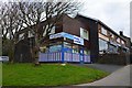
Bramley Laundrette, Whitecote Hill
Signs proclaimed this business still open despite the Covid-19 restrictions. Signage but not the name has changed since 2011 Image
Image: © Stephen Craven
Taken: 19 Apr 2020
0.01 miles
4
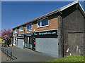
Row of shops, Whitecote Hill, Bramley
The retail units presently comprise an estate agent, hair salon. vaping shop and cafe (plus a launderette set back at the far end). Only the hair salon is unchanged in its name and use since 2006 Image
Image: © Stephen Craven
Taken: 19 Apr 2020
0.01 miles

6
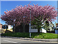
Cherry blossom on Whitecote Hill
The trees are at the end of Whitecote Gardens.
Image: © Stephen Craven
Taken: 19 Apr 2020
0.01 miles
7
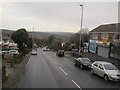
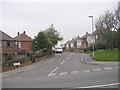
Whitecote Hill
A few shop units on the right, one of them vacant.
Taken from the top deck of the 86 bus to Rodley.
Image: © Stephen Craven
Taken: 16 Jan 2016
0.02 miles
8
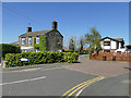
Mount Pleasant, off Whitecote Hill, Bramley
The name originally referred to a court of terraced cottages as shown on the 1908 map, but only the house at the entrance (left) remains; the cottages have been replaced with more modern dwellings and the road is on a new alignment.
Image: © Stephen Craven
Taken: 19 Apr 2020
0.02 miles
9
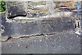
Benchmark on the roadside wall of #24 Whitecote Hill
Ordnance Survey cut mark benchmark described on the Bench Mark Database at https://www.bench-marks.org.uk/bm83904
Image: © Roger Templeman
Taken: 18 Apr 2017
0.02 miles
10
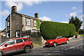
#24 Whitecote Hill
There is an OS benchmark Image on the base stone above the pavement at the wall corner in front of the car in the middle of the image
Image: © Roger Templeman
Taken: 18 Apr 2017
0.02 miles