IMAGES TAKEN NEAR TO
Aston Drive, LEEDS, LS13 2DY
Introduction
This page details the photographs taken nearby to Aston Drive, LS13 2DY by members of the Geograph project.
The Geograph project started in 2005 with the aim of publishing, organising and preserving representative images for every square kilometre of Great Britain, Ireland and the Isle of Man.

There are currently over 7.5m images from over14,400 individuals and you can help contribute to the project by visiting https://www.geograph.org.uk
Image Map
Images are licensed for reuse under creativecommons.org/licenses/by-sa/2.0
Notes
- Clicking on the map will re-center to the selected point.
- The higher the marker number, the further away the image location is from the centre of the postcode.
Image Listing (318 Images Found)
Images are licensed for reuse under creativecommons.org/licenses/by-sa/2.0
Image
Details
Distance
3
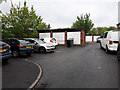
Lock-up garages, Aston Terrace, Bramley
There seems to be a need for additional parking here, or it may be that as so often happens the owners prefer to store tools and other stuff in the garage and park the car on the road or pavement instead.
Image: © Stephen Craven
Taken: 29 Apr 2020
0.03 miles
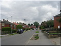
4
Blocked footpath from Kings Approach to Aston Drive
The western end of the path seen in Image running along the backs of houses on Aston Drive, has been officially closed "to increase the safety and security of residents".
The 1852 6-inch map shows it as part of an ancient track from Bramley village to the large farm at Hill Top. Local people still use it as a short cut to and from the local shops or bus stop. It is part of the same path as seen in Image
Image: © Stephen Craven
Taken: 2 Aug 2015
0.04 miles
5
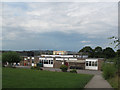
Raynville Primary School (2)
The upper building, seen from the path alongside the school boundary.
Image: © Stephen Craven
Taken: 2 Aug 2015
0.04 miles
6
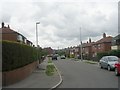
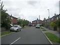
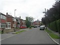
Aston Drive - looking towards Aston Mount
Image: © Betty Longbottom
Taken: 12 Jul 2011
0.04 miles
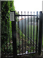
7
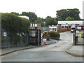
Raynville Primary School, reopened
In the recovery from the 2020 Covid-19 crisis, primary schools were allowed to reopen selectively from the beginning of June. The 'one way' signs on the gate suggest that movement into and around the site was being carefully controlled.
Image: © Stephen Craven
Taken: 9 Jun 2020
0.05 miles
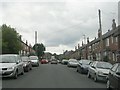
10
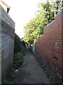
Ancient right of way off Eightlands Lane
This footpath cuts across two modern streets at an odd angle, suggesting earlier origins, and indeed the 1852 6-inch map shows it as part of an ancient track from Bramley village to the large farm at Hill Top. Local people still use it as a short cut to and from the local shops or bus stop.
It is part of the same path as seen in Image and Image
Image: © Stephen Craven
Taken: 29 Aug 2015
0.05 miles