IMAGES TAKEN NEAR TO
Park Place, LEEDS, LS1 2RX
Introduction
This page details the photographs taken nearby to Park Place, LS1 2RX by members of the Geograph project.
The Geograph project started in 2005 with the aim of publishing, organising and preserving representative images for every square kilometre of Great Britain, Ireland and the Isle of Man.

There are currently over 7.5m images from over14,400 individuals and you can help contribute to the project by visiting https://www.geograph.org.uk
Image Map
Images are licensed for reuse under creativecommons.org/licenses/by-sa/2.0
Notes
- Clicking on the map will re-center to the selected point.
- The higher the marker number, the further away the image location is from the centre of the postcode.
Image Listing (1778 Images Found)
Images are licensed for reuse under creativecommons.org/licenses/by-sa/2.0
Image
Details
Distance
1
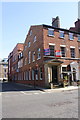
Office to let at #12 Park Place at Central Street junction
There is an OS benchmark Image on a stone in the left hand side of the building near its front corner
Image: © Roger Templeman
Taken: 18 Apr 2017
0.01 miles
2
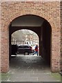
Park Square, Leeds
Seen through the passage leading to the east side of Park Square from Park Cross St.
Image: © Rich Tea
Taken: 26 Jan 2006
0.01 miles
4
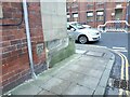
Benchmark on Central Street
I've walked this way several times but only just noticed this benchmark although it's more prominent than many of them. The 1934 OS map gives it a value of 116.60 feet (35.54m). See Image for a close look.
Image: © Stephen Craven
Taken: 20 Jan 2023
0.01 miles
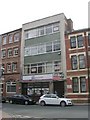
5
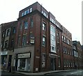
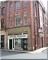
Eyton House, Central Street, Leeds
An office block dating from 1931, see Image The shop unit on the ground floor, formerly Central Fillings Image, is now occupied by LS1-FortyFive.
Image: © Stephen Craven
Taken: 3 Aug 2021
0.01 miles
6
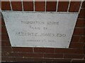
Foundation stone of Eyton House
An office block dating from 1931, for context see Image Could those attending the ceremony on the first day of a new decade have imagined how that decade would end?
Image: © Stephen Craven
Taken: 3 Aug 2021
0.01 miles
7
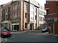
Central Street
Looking at Central Street across St Paul's Street.
Image: © Rich Tea
Taken: 29 Oct 2006
0.01 miles
9
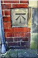
Benchmark on #12 Park Place
Ordnance Survey cut mark benchmark described on the Bench Mark Database at http://www.bench-marks.org.uk/bm27839
Image: © Roger Templeman
Taken: 18 Apr 2017
0.01 miles
10
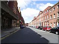
Park Place.
Originally the road was where the gardens to the houses on the right were laid out, and in fact there was a clear view down to the River Aire from here, the Park Estate was developed in the 1770's, then when the railways came and the merchants had large warehouses built the residents moved out to the clean air of Headingley.
Image: © Stanley Walker
Taken: 29 Jul 2007
0.01 miles