IMAGES TAKEN NEAR TO
Lowfields Avenue, LEEDS, LS12 6HH
Introduction
This page details the photographs taken nearby to Lowfields Avenue, LS12 6HH by members of the Geograph project.
The Geograph project started in 2005 with the aim of publishing, organising and preserving representative images for every square kilometre of Great Britain, Ireland and the Isle of Man.

There are currently over 7.5m images from over14,400 individuals and you can help contribute to the project by visiting https://www.geograph.org.uk
Image Map
Images are licensed for reuse under creativecommons.org/licenses/by-sa/2.0
Notes
- Clicking on the map will re-center to the selected point.
- The higher the marker number, the further away the image location is from the centre of the postcode.
Image Listing (69 Images Found)
Images are licensed for reuse under creativecommons.org/licenses/by-sa/2.0
Image
Details
Distance
3
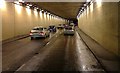
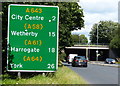
A643 Ingram Distributor Road Tunnel
The A643 Elland Road is regarded locally as a part of the Leeds Inner Ring Road and runs south west from the city through Morley, Cleckheaton, Gomersall and Brighouse to terminate west of Huddersfield at junction 23 of the M62 (Trans Pennine Motorway).
Image: © Steve Partridge
Taken: 5 Dec 2007
0.09 miles
4
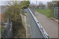
Matthew Murray Tunnel, Outer Wall
The outer wall of the tunnel Image is visible along the west side where it abuts an industrial estate. The tree growth must make access for inspection difficult.
Image: © Richard Kay
Taken: 12 Apr 2010
0.10 miles
5
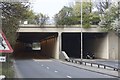
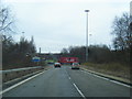
Matthew Murray Tunnel, A643
The south portal of the tunnel, which takes its name from the now demolished Matthew Murray School. The tunnel was built specifically to shield the school from the intrusion and noise of the Ingram Road Distributor, A643, which feeds traffic from the M621 Motorway into the city centre of Leeds.
Image: © Richard Kay
Taken: 12 Apr 2010
0.10 miles
6
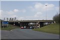
Elland Road West Bridge M621
The bridge carries the M621motorway over the A643 at the end of the Ingram Road Distributor. prestressed concrete beams carry a reinforced concrete deck slab, all supported by reinforced concrete piers.
Image: © Richard Kay
Taken: 12 Apr 2010
0.11 miles
7
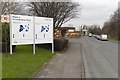
Maple and Confederation Park, Low Fields Avenue
Light industrial units and offices.
Image: © Mark Anderson
Taken: 22 Mar 2018
0.12 miles
8
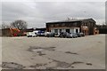
R J Howard Engineers Ltd, Lowfields Road
Civil engineers.
Image: © Mark Anderson
Taken: 22 Mar 2018
0.13 miles
9
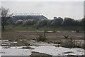
Site of former Matthew Murray School
The school, now demolished, gave its name to the nearby tunnel Image The outline of the east wall of the tunnel, which is covered in an earth mound, can be seen behind the horses. Elland Road Football stadium can be seen in the background.
Image: © Richard Kay
Taken: 12 Apr 2010
0.14 miles
10
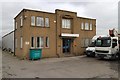
Viceroy House, Lowfields Road
It looks like this business hires out raised access equipment.
Image: © Mark Anderson
Taken: 22 Mar 2018
0.14 miles