IMAGES TAKEN NEAR TO
Wood Lane Court, LEEDS, LS12 6GZ
Introduction
This page details the photographs taken nearby to Wood Lane Court, LS12 6GZ by members of the Geograph project.
The Geograph project started in 2005 with the aim of publishing, organising and preserving representative images for every square kilometre of Great Britain, Ireland and the Isle of Man.

There are currently over 7.5m images from over14,400 individuals and you can help contribute to the project by visiting https://www.geograph.org.uk
Image Map
Images are licensed for reuse under creativecommons.org/licenses/by-sa/2.0
Notes
- Clicking on the map will re-center to the selected point.
- The higher the marker number, the further away the image location is from the centre of the postcode.
Image Listing (122 Images Found)
Images are licensed for reuse under creativecommons.org/licenses/by-sa/2.0
Image
Details
Distance
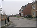
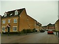
1
Wood Lane Court
Part of a fairly recent housing development. The buildings to the right are on the site of the former Mabor Magnesia Works.
Image: © Stephen Craven
Taken: 29 Nov 2020
0.01 miles
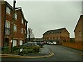
2
Footpath off Dunlop Avenue
The footpath is on the driveway to a farm.
Image: © Humphrey Bolton
Taken: 8 Jun 2019
0.02 miles
3
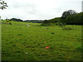
Mound in a field near Dunlop Avenue, Leeds
There is a disused air shaft not far away, so this mound might be connected to mining activity.
Image: © Humphrey Bolton
Taken: 8 Jun 2019
0.03 miles
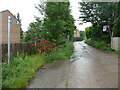
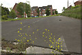
4
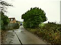
The start of Wood Lane
The first section of this public footpath is concrete surfaced as it acts as the access to Ochre House Farm, now more of a small industrial estate than a working farm.
Image: © Stephen Craven
Taken: 29 Nov 2020
0.03 miles
5
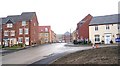
Wimpey Development - Dunlop Avenue, Whitehall Road
Image: © Betty Longbottom
Taken: 4 Jan 2008
0.05 miles
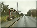
8
Disused Tarmac, Dunlop Avenue
I assume that the road junction was altered when the houses were built.
Image: © Mark Anderson
Taken: 14 Jun 2017
0.05 miles
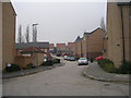
9
Dunlop Avenue and Ironstone Drive
Part of a fairly recent housing development on the site of the former Dunlop and Ranken engineering works, hence one of the names. The name Ironstone Drive probably comes from the one-time Farnley ironworks not far away. See also Image
Image: © Stephen Craven
Taken: 29 Nov 2020
0.06 miles