IMAGES TAKEN NEAR TO
Gelderd Road, LEEDS, LS12 6DL
Introduction
This page details the photographs taken nearby to Gelderd Road, LS12 6DL by members of the Geograph project.
The Geograph project started in 2005 with the aim of publishing, organising and preserving representative images for every square kilometre of Great Britain, Ireland and the Isle of Man.

There are currently over 7.5m images from over14,400 individuals and you can help contribute to the project by visiting https://www.geograph.org.uk
Image Map
Images are licensed for reuse under creativecommons.org/licenses/by-sa/2.0
Notes
- Clicking on the map will re-center to the selected point.
- The higher the marker number, the further away the image location is from the centre of the postcode.
Image Listing (32 Images Found)
Images are licensed for reuse under creativecommons.org/licenses/by-sa/2.0
Image
Details
Distance
1
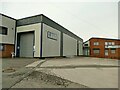
Temban Fabrications, Gelderd Road, Leeds
"Specialising in all aspects of industrial metal and aluminium roofing and cladding systems" (from their website).
Image: © Stephen Craven
Taken: 31 Jan 2021
0.01 miles
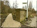
2
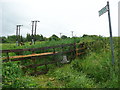
Blocked footpath off the A62, Leeds
The stile is very difficult to use, and there is thick vegetation on the line of the path.
Image: © Humphrey Bolton
Taken: 8 Jun 2019
0.03 miles
3
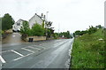
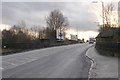
The A62 passing Credonemo, Leeds
Credonemo is the name on the large-scale OS map, but it is not clear what it refers to. The pair of houses are on the 1893 1:2500 map and there was a Congregational chapel to the left.
Image: © Humphrey Bolton
Taken: 8 Jun 2019
0.04 miles
4
Railway Line from Bridge MDL1/43 - Gelderd Road
Image: © Betty Longbottom
Taken: 8 Jan 2008
0.07 miles
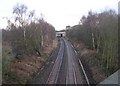
5
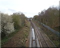
Railway towards Cottingley Station
From the bridge on Gelderd Road (A62).
Image: © JThomas
Taken: 14 Feb 2020
0.08 miles
6
A deceptively good footpath
I came across this public footpath with a clean gravel surface and optimistically expected it to run the full 500 metres to Honeybourne Road. No, it's Network Rail who have just resurfaced the first 50m to their rail access point. Beyond that it's mud.
Image: © Stephen Craven
Taken: 31 Jan 2021
0.09 miles
7
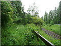
Footpath alongside the railway off the A62, Leeds
Lots of lovely wet vegetation - not a path to walk on a rainy day!
Image: © Humphrey Bolton
Taken: 8 Jun 2019
0.09 miles
8
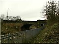
Gelderd Road railway bridge across the north transpennine line
The twin tracks of the main Leeds to Manchester railway pass under one wide arch; to the right a narrower arch once accommodated a single-line chord to the LNWR's Heaton Lodge branch. See Image for a view from the bridge.
Image: © Stephen Craven
Taken: 31 Jan 2021
0.09 miles
9
Bridge MDL1/43 - A62 - Gelderd Road
Image: © Betty Longbottom
Taken: 8 Jan 2008
0.10 miles
10
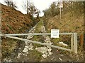
Closed access road to Hilltop Cemetery, Leeds
The Hill Top Jewish Cemetery opened in 1873 and contains the burial grounds for a number of synagogues in Leeds. Although the "No entry" notice on the gate forbidding access for safety reasons is dated August 2020, the cemetery itself was permanently closed in 2008 because some parts of the cemetery had collapsed on more than one occasion into old coal workings. We don't seem to have any photos of the cemetery itself on this site. Burials now take place in the newer burial ground across the road Image
Image: © Stephen Craven
Taken: 31 Jan 2021
0.10 miles