IMAGES TAKEN NEAR TO
Kirkdale Crescent, LEEDS, LS12 6AS
Introduction
This page details the photographs taken nearby to Kirkdale Crescent, LS12 6AS by members of the Geograph project.
The Geograph project started in 2005 with the aim of publishing, organising and preserving representative images for every square kilometre of Great Britain, Ireland and the Isle of Man.

There are currently over 7.5m images from over14,400 individuals and you can help contribute to the project by visiting https://www.geograph.org.uk
Image Map
Images are licensed for reuse under creativecommons.org/licenses/by-sa/2.0
Notes
- Clicking on the map will re-center to the selected point.
- The higher the marker number, the further away the image location is from the centre of the postcode.
Image Listing (84 Images Found)
Images are licensed for reuse under creativecommons.org/licenses/by-sa/2.0
Image
Details
Distance
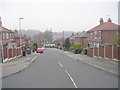
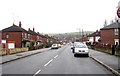
1
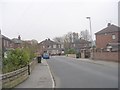
Kirkdale Crescent - Kirkdale Crescent
Image: © Betty Longbottom
Taken: 16 Nov 2011
0.02 miles
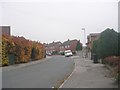
3
Kirkdale Mount - Kirkdale Crescent
Image: © Betty Longbottom
Taken: 16 Nov 2011
0.05 miles
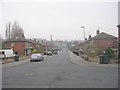
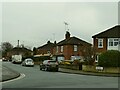
4
Kirkdale Crescent - Kirkdale Drive
Image: © Betty Longbottom
Taken: 16 Nov 2011
0.06 miles
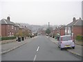
5
Kirkdale Mount - Kirkdale Crescent
Image: © Betty Longbottom
Taken: 16 Nov 2011
0.07 miles
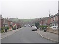
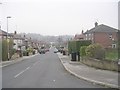
6
Kirkdale Crescent
Note the roofers at work. The housing estate was built, probably in the 1940s/50s, on the site of the former Weighing Bridge Farm.
Image: © Stephen Craven
Taken: 29 Nov 2020
0.07 miles
10
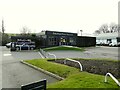
Rolls-Royce dealer, Wortley
One of many car dealerships along this section of the Ring Road.
Image: © Stephen Craven
Taken: 31 Jan 2021
0.12 miles