IMAGES TAKEN NEAR TO
Whitehall Road, LEEDS, LS12 6AQ
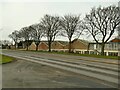
Introduction
This page details the photographs taken nearby to Whitehall Road, LS12 6AQ by members of the Geograph project.
The Geograph project started in 2005 with the aim of publishing, organising and preserving representative images for every square kilometre of Great Britain, Ireland and the Isle of Man.

There are currently over 7.5m images from over14,400 individuals and you can help contribute to the project by visiting https://www.geograph.org.uk
Image Map
Images are licensed for reuse under creativecommons.org/licenses/by-sa/2.0
Notes
- Clicking on the map will re-center to the selected point.
- The higher the marker number, the further away the image location is from the centre of the postcode.
Image Listing (96 Images Found)
Images are licensed for reuse under creativecommons.org/licenses/by-sa/2.0
Image
Details
Distance
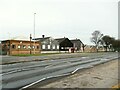
1
Rear of Pland Stainless Steel factory
The sign-writing looks quite old. It looks like there was once similar writing on the south-western face of the factory, but the prevailing winds have made that almost completely illegible.
Image: © Mark Anderson
Taken: 13 Mar 2018
0.03 miles
2
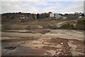
Former site of Wortley Low Mills
Once occupied by Glover's Chemicals and some engineering works.
Image: © Mark Anderson
Taken: 13 Mar 2018
0.05 miles
4
Pland Stainless Steel, Wortley (1)
A large factory adjacent to the Ring Road, supplying "bowls, basins, sinks, sanitary ware and washroom equipment to the Hospital and public sectors" according to their website. This looks to be the offices end of the site.
Image: © Stephen Craven
Taken: 31 Jan 2021
0.05 miles
5
Pland Stainless Steel, Wortley (2)
A large factory adjacent to the Ring Road, supplying "bowls, basins, sinks, sanitary ware and washroom equipment to the Hospital and public sectors" according to their website.
Image: © Stephen Craven
Taken: 31 Jan 2021
0.06 miles
6
Pland Stainless Steel, Wortley (3)
A large factory adjacent to the Ring Road, supplying "bowls, basins, sinks, sanitary ware and washroom equipment to the Hospital and public sectors" according to their website. This looks to be the oldest part of the site. See Image for the other side.
Image: © Stephen Craven
Taken: 31 Jan 2021
0.07 miles
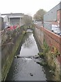
7
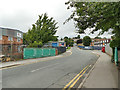
Royds Lane, looking north
The green panels are the parapet of a bridge over the Wortley Beck.
Image: © Stephen Craven
Taken: 29 Jun 2020
0.07 miles
9
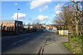
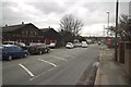
Royds Lane north of Low Wortley Ring Road
Royds Lane to the north of the A6110. The road heads north to meet the A58 Whitehall Road.
Image: © DS Pugh
Taken: 22 Feb 2025
0.07 miles
10
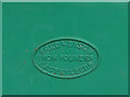
Maker's plaque on Royds Lane bridge
The bridge was made by Frederick Dyson, Iron Founder, East Street, Leeds. See Image for context. The firm was in business from 1882 to 1970, and a fuller history can be found online at http://www.oakwoodchurch.info/Oak%20Leaves%20Part%2012%20-%20A%20Roundhay%20Iron%20Founder%20Frederick%20Dyson%201847-1912%20and%20his%20work%20by%20Tony%20Dyson%20and%20Graham%20Hills.pdf
Image: © Stephen Craven
Taken: 29 Jun 2020
0.07 miles