IMAGES TAKEN NEAR TO
Lodge Hill Walk, LEEDS, LS12 5TP
Introduction
This page details the photographs taken nearby to Lodge Hill Walk, LS12 5TP by members of the Geograph project.
The Geograph project started in 2005 with the aim of publishing, organising and preserving representative images for every square kilometre of Great Britain, Ireland and the Isle of Man.

There are currently over 7.5m images from over14,400 individuals and you can help contribute to the project by visiting https://www.geograph.org.uk
Image Map
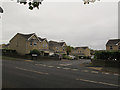
Images are licensed for reuse under creativecommons.org/licenses/by-sa/2.0
Notes
- Clicking on the map will re-center to the selected point.
- The higher the marker number, the further away the image location is from the centre of the postcode.
Image Listing (65 Images Found)
Images are licensed for reuse under creativecommons.org/licenses/by-sa/2.0
Image
Details
Distance
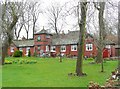
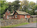
3
Memorial Cottages, New Farnley - detail
See Image for context.
Image: © Stephen Craven
Taken: 18 Oct 2015
0.09 miles
4
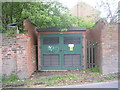
Electricity Substation No 3886 - Lawns Lane
Image: © Betty Longbottom
Taken: 16 May 2011
0.09 miles
6
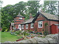
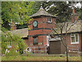
Memorial Cottages, New Farnley
I have not established what they are a memorial to. See also Image
Image: © Stephen Craven
Taken: 18 Oct 2015
0.09 miles
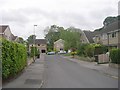
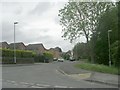
7
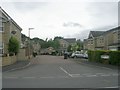
Stephenson Drive
Recent housing in what is still essentially a rural area - see Image only 100m away.
Image: © Stephen Craven
Taken: 18 Oct 2015
0.10 miles
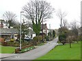
8
Barkers Well Fold - Stephenson Drive
Image: © Betty Longbottom
Taken: 16 May 2011
0.10 miles