IMAGES TAKEN NEAR TO
Ring Road, LEEDS, LS12 5SG
Introduction
This page details the photographs taken nearby to Ring Road, LS12 5SG by members of the Geograph project.
The Geograph project started in 2005 with the aim of publishing, organising and preserving representative images for every square kilometre of Great Britain, Ireland and the Isle of Man.

There are currently over 7.5m images from over14,400 individuals and you can help contribute to the project by visiting https://www.geograph.org.uk
Image Map
Images are licensed for reuse under creativecommons.org/licenses/by-sa/2.0
Notes
- Clicking on the map will re-center to the selected point.
- The higher the marker number, the further away the image location is from the centre of the postcode.
Image Listing (168 Images Found)
Images are licensed for reuse under creativecommons.org/licenses/by-sa/2.0
Image
Details
Distance
1
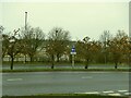
Fruit trees on the ring road
Four trees in the central reservation of the Leeds Ring Road in Lower Wortley, bearing late autumn fruit - possibly quinces or crab apples? It would be risky at most times to run across the road to check, and the fruit would be so polluted I wouldn't wish to eat it.
Image: © Stephen Craven
Taken: 29 Nov 2020
0.02 miles
2
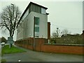
Wortley Beck Health Centre
Well named, as the beck flows immediately behind it Image
Image: © Stephen Craven
Taken: 29 Nov 2020
0.02 miles
4
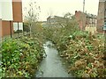
Wortley Beck behind the Health Centre
Image: © Stephen Craven
Taken: 29 Nov 2020
0.03 miles
8
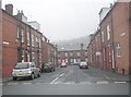
Bangor Terrace - viewed from Cow Close Road
Image: © Betty Longbottom
Taken: 8 Nov 2011
0.05 miles