IMAGES TAKEN NEAR TO
Lytham Grove, LEEDS, LS12 5PL
Introduction
This page details the photographs taken nearby to Lytham Grove, LS12 5PL by members of the Geograph project.
The Geograph project started in 2005 with the aim of publishing, organising and preserving representative images for every square kilometre of Great Britain, Ireland and the Isle of Man.

There are currently over 7.5m images from over14,400 individuals and you can help contribute to the project by visiting https://www.geograph.org.uk
Image Map
Images are licensed for reuse under creativecommons.org/licenses/by-sa/2.0
Notes
- Clicking on the map will re-center to the selected point.
- The higher the marker number, the further away the image location is from the centre of the postcode.
Image Listing (173 Images Found)
Images are licensed for reuse under creativecommons.org/licenses/by-sa/2.0
Image
Details
Distance
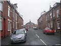
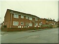
2
Lytham Place
Note the washing lines across the street, complete with pegs.
Image: © Betty Longbottom
Taken: 27 Nov 2007
0.02 miles
5
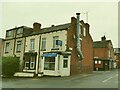
My Ngan, Branch Road
A Chinese takeaway.
Image: © Stephen Craven
Taken: 29 Nov 2020
0.03 miles
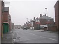
9
Site of the Branch Road mission room
The parish of Farnley once had a mission room and Sunday school on this corner, as shown on old maps. It was closed some time in the 1970s and housing is now on the site.
Image: © Stephen Craven
Taken: 29 Nov 2020
0.03 miles
10
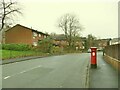
Postbox on Cow Close Road
See Image for a close look.
Image: © Stephen Craven
Taken: 29 Nov 2020
0.04 miles