IMAGES TAKEN NEAR TO
Wood Grove, LEEDS, LS12 5NN
Introduction
This page details the photographs taken nearby to Wood Grove, LS12 5NN by members of the Geograph project.
The Geograph project started in 2005 with the aim of publishing, organising and preserving representative images for every square kilometre of Great Britain, Ireland and the Isle of Man.

There are currently over 7.5m images from over14,400 individuals and you can help contribute to the project by visiting https://www.geograph.org.uk
Image Map
Images are licensed for reuse under creativecommons.org/licenses/by-sa/2.0
Notes
- Clicking on the map will re-center to the selected point.
- The higher the marker number, the further away the image location is from the centre of the postcode.
Image Listing (71 Images Found)
Images are licensed for reuse under creativecommons.org/licenses/by-sa/2.0
Image
Details
Distance
1
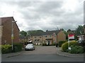
Pitchstone Court - Greenmoor Avenue
Image: © Betty Longbottom
Taken: 10 May 2011
0.05 miles
4
Greenmoor Avenue - Cornerstone Fold
Image: © Betty Longbottom
Taken: 10 May 2011
0.08 miles
5
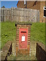
George VI postbox in Gamble Lane, Farnley
Image: © Schlosser67
Taken: 2 Oct 2016
0.09 miles
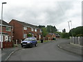
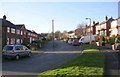
7
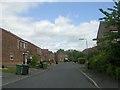
Greenmoor Avenue, off Wood Lane
A housing estate built on old (and presumably infilled) quarry workings.
Image: © Stephen Craven
Taken: 11 Jun 2020
0.09 miles
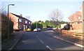
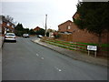
9
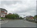
Wood Lane - viewed from Gamble Lane
Image: © Betty Longbottom
Taken: 10 May 2011
0.09 miles
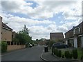
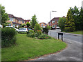
10
Cornerstone Fold - looking towards Sandstone Drive
Image: © Betty Longbottom
Taken: 10 May 2011
0.10 miles