IMAGES TAKEN NEAR TO
Ring Road, LEEDS, LS12 5LU
Introduction
This page details the photographs taken nearby to Ring Road, LS12 5LU by members of the Geograph project.
The Geograph project started in 2005 with the aim of publishing, organising and preserving representative images for every square kilometre of Great Britain, Ireland and the Isle of Man.

There are currently over 7.5m images from over14,400 individuals and you can help contribute to the project by visiting https://www.geograph.org.uk
Image Map
Images are licensed for reuse under creativecommons.org/licenses/by-sa/2.0
Notes
- Clicking on the map will re-center to the selected point.
- The higher the marker number, the further away the image location is from the centre of the postcode.
Image Listing (114 Images Found)
Images are licensed for reuse under creativecommons.org/licenses/by-sa/2.0
Image
Details
Distance
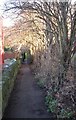
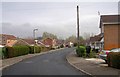
1
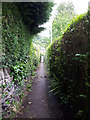
Path from Post Hill Court to the Leeds ring road
Like many such urban paths it more-or-less follows the route of a previous field path.
Image: © Stephen Craven
Taken: 11 Jun 2020
0.03 miles
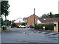
2
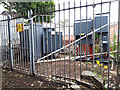
Substation, Post Hill Court
This installation seems to have two names - Park Spring Farnley and Swinnow Lane South. Perhaps the incoming supply is split to serve the two areas independently.
Image: © Stephen Craven
Taken: 11 Jun 2020
0.04 miles
4
Footpath off Wood Lane, Farnley
This path was here long before the houses were built. it went to a corn mill off Pudsey Road.
Image: © Humphrey Bolton
Taken: 22 Sep 2020
0.05 miles
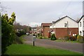
6
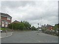
Wood Lane - viewed from Gamble Lane
Image: © Betty Longbottom
Taken: 10 May 2011
0.06 miles
7
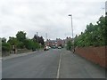
Water Lane - viewed from Tong Gate
Image: © Betty Longbottom
Taken: 10 May 2011
0.06 miles
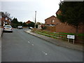
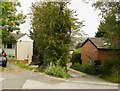
10
Hare Farm Close
I can't see 'Hare Farm' marked on old maps of the area, though there was a Hare Park Mill nearby.
Image: © Stephen Craven
Taken: 11 Jun 2020
0.08 miles